View on map
© MapLibre | OpenStreetMap contributors
1%
2%
4%
6%
8%
10%
12%
15%
20%

Le Cohard from Pinsot

3.0
3 reviews | Elevation profile | 2 photos
Tips nearby
Le Cohard from Pinsot
transparant thumb
transparant thumb
transparant thumb
transparant thumb
transparant thumb
transparant thumb
Your achievable time
Calculating based on your best performances...
Relaxed
Maximum
W/kg
W/kg
W/kg
Analyze your climbing performance
Detailed insight into your climbing performance & automatically check off climbs
Based on your best performances.
Your best attempt:
Number of attempts:
Elevation profile Le Cohard from Pinsot

Statistics

Difficulty points 532
Length 2.5 mi
Average gradient 11.1%
Steepest segment 16.1%
Total ascent 1467 ft

Short recap

Beautiful scenery
8 hairpin turns
#89 toughest climb of Grenoble
#84 average steepest climb of Auvergne-Rhône-Alpes
Feedback about this climb?
Show climbs nearby Export to GPS device

Le Cohard from Pinsot is a climb in the region Grenoble. It is 2.5 mi long and bridges 1467 ft of vertical ascent with an average gradient of 11.1%, resulting in a difficulty score of 532. The top of the ascent is located at 3917 ft above sea level. Climbfinder users shared 3 reviews of this climb and uploaded 2 photos.

3.0 by pyralp6538
This is an automatic translation, the original language is: French.
Short but brutal climb, especially up to Gleysin. The road surface is average to poor in places, but passable with a road bike. Narrow road, little used in spring, landscaped on the upper part. The steepness of the slope is clearly visible on the descent...be careful.... read more

Photos (2)

Le Cohard from Pinsot
transparant thumb
transparant thumb
transparant thumb
transparant thumb

Your uploads (max 4)

Welcome! Please activate your account if you would like to share something. Look for the verification email in your inbox.

If you want to upload your photos, you need to create an account. It only takes 1 minute and it's completely free.

  • Receive free climbfinder goodies for your reviews & photos.
  • Create a bucket list and check off conquered climbs.
  • Add missing climbs.
Continue with GoogleContinue with Google Continue with FacebookContinue with Facebook Continue with AppleContinue with Apple Sign up with email
By signing up you agree to our terms of service and confirm that you have read our privacy & content policy.

Reviews (3)

5.0
4.0
3.0
2.0
1.0
pyralp6538
2 w 3.0
This is an automatic translation, the original language is: French. Show original

Short but brutal climb, especially up to Gleysin. The road surface is average to poor in places, but passable with a road bike. Narrow road, little used in spring, landscaped on the upper part. The steepness of the slope is clearly visible on the descent...be careful.

Montée courte mais brutal surtout jusqu'à Gleysin. Le revêtement est moyen voire mauvais par endroits mais ça passe avec un vélo de route. Route étroite et peu fréquentée au printemps, paysagée sur la partie haute. On mesure bien la raideur de la pente à la descente...prudence.

Dashboard
LucSou
1 y 3.0
This is an automatic translation, the original language is: French. Show original

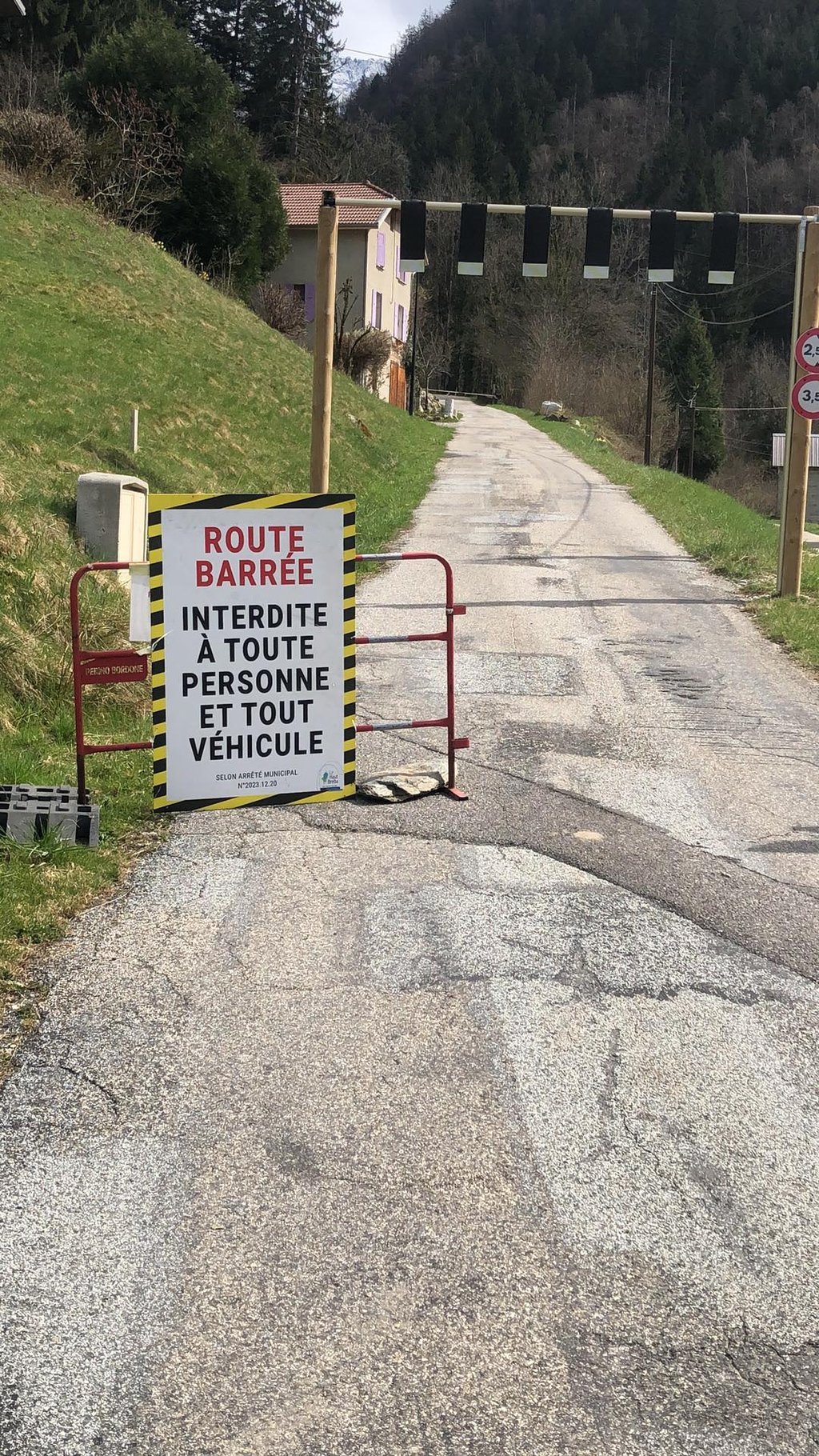
Just to warn my fellow cyclists that on 03/04/2025 the road is closed due to a landslide.
According to the local person who gave me the information, this happens from time to time, so watch out.

Juste pour prévenir mes confrère cyclistes qu'en date du 03/04/2025 la route est fermée pour cause d'éboulement.
D'après l'autochtone qui ma donné l'info ça arrive de temps en temps alors méfiance.

Le Cohard from Pinsot
Dashboard
SimNono
1 y 3.0
This is an automatic translation, the original language is: French. Show original

A little diversions with a bang! The road is average but there's no-one around. Nice view of the Oule valley at the top.

Un petit détour qui claque ! La route est moyenne mais il n'y a personne. Belle vue sur le vallon de l'Oule en haut.

Le Cohard from Pinsot
Dashboard

Climbing times

5 mph 00:30:13
7 mph 00:21:23
9 mph 00:16:40
12 mph 00:12:31

Road surface condition

0% 0% 0%
Based on 0 votes
Share your knowledge. What was the road condition during your ascent?

Traffic

0% 0% 0%
Based on 0 votes
Your experience counts. How much traffic did you encounter during the climb?

Frequently Asked Questions

Le Cohard from Pinsot is a challenging ascent. For this type of climbing, we recommend mountain gearing, specifically a compact system. This means a small front chainring of 34 teeth, combined with a rear cassette where, depending on your level, strength, and experience, you choose a sprocket with 30, 32, or even 34 teeth. Remember that a smooth cadence is always more efficient!

Le Cohard from Pinsot is a serious climb and falls into the 2nd category. With a good basic fitness level, even without much cycling experience, you can complete this climb just fine. However, a bike with climbing gears is a must. Without experience or training, it will be really tough – but that’s part of the challenge!

Le Cohard from Pinsot is 2.5 mi long.

The average gradient of Le Cohard from Pinsot is 11.1%.

Le Cohard from Pinsot has a steepest segment with an average gradient of 16.1%.

The summit of Le Cohard from Pinsot is at 3917 ft.

At a slow pace of 5 mph, it takes about 00:30:13 to climb Le Cohard from Pinsot. At 7 mph the time is 00:21:23, and at 9 mph 00:16:40. For the fastest cyclists, 00:12:31 is an achievable time.

Le Cohard from Pinsot is located in the region Isère in France.

This page is better in the app

Climbfinder app
Climbfinder
(Free)
Open