| 9 hairpin turns |
| #52 toughest climb of Trentino-South Tyrol |
| #40 most elevation gain of Italy |
| #62 longest climb of Europe |
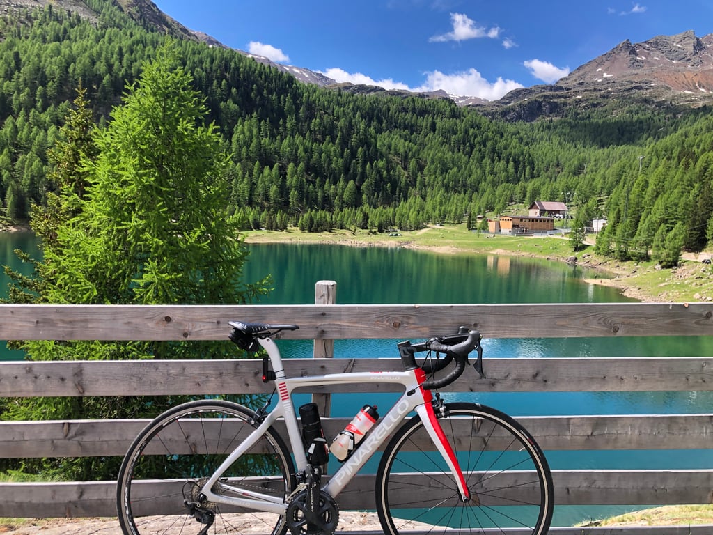
Lago di Fontana Bianca / Weissbrunnsee via Ultental is a climb in the region Bolzano. It is 22.9 mi long and bridges 5446 ft of vertical ascent with an average gradient of 4.5%, resulting in a difficulty score of 1186. The top of the ascent is located at 6217 ft above sea level. Climbfinder users shared 1 review/story of this climb and uploaded 8 photos.
Road names: Ultner Straße - Via Ultimo & LS/SP9
5.0 by patrickbaertThis is an automatic translation, the original language is: Dutch.The Ultendal/Val d'Ultimo is a long climb in a tributary valley of the wide Adige valley, right against Merano in bilingual South Tyrol, which was made possible because the road was built in the distant past (1905) for the construction of the dams in the valley. Spicy start in Lana with several hairpin bends between cypress trees and especially apple orchards up the mountainside. Followed by a 25 km long middle section, with the exception of 2 km, mainly slightly uphill with sporadic even... read more

Welcome! Please activate your account if you would like to share something. Look for the verification email in your inbox.
If you want to upload your photos, you need to create an account. It only takes 1 minute and it's completely free.
The Ultendal/Val d'Ultimo is a long climb in a tributary valley of the wide Adige valley, right against Merano in bilingual South Tyrol, which was made possible because the road was built in the distant past (1905) for the construction of the dams in the valley.
Spicy start in Lana with several hairpin bends between cypress trees and especially apple orchards up the mountainside.
Followed by a 25 km long middle section, with the exception of 2 km, mainly slightly uphill with sporadic even downhill stretches on wide (busy) road from village to village. Always near the river and some larger lakes created by dams.
In Sankt Gertraud/Santa Gertrude the last village virtually ends the inhabited world. A narrow road meanders on for the last 5 tough km. with some hairpin bends via some waterfalls through the pine forest to reach the top at a last reservoir where you can cycle right past until the end of the road at the Weissbrunn mountain restaurant.
You are surrounded by snowy peaks as the last part is effectively part of the Stelvio National Park.
Practical:
Final part no traffic,busy on the way (June 2024).
Poor road surface in final section.
On the way supplies in small village and
at the finish (although closed at mine).
There are 3 illuminated tunnels in the middle section , one of which is 995 m long, but provide flashing bike tail lights.
Part along Zoggler stausee has separate gravel/MTB bike path .
Start in Lana can be reached from tourist Merano via special red arrowed cycle route.
Not to be underestimated long beautiful typical side valley climb out of category with solid natural lock in National Park!
Het Ultendal/Val d'Ultimo is een lange klim in een zijdal van de brede Adige vallei, vlak tegen Merano in tweetalig Zuid Tirol, die werd mogelijk gemaakt doordat de weg in een ver verleden (1905) aangelegd werd voor de bouw van de stuwdammen in het dal.
Pittige start in Lana met enkele haarspeldbochten tussen cipressen en vooral de appelboomgaarden de bergflank omhoog.
Gevolgd door een 25 km. lang middendeel, met op uitzondering van 2 km., voornamelijk licht stijgend met sporadisch zelfs dalende stroken op brede (drukke) weg van dorpje tot dorpje. Steeds in de nabijheid van de rivier en enkele grotere meren door stuwdammen gecreëerd.
In Sankt Gertraud/Santa Gertrude het laatste dorp eindigt nagenoeg de bewoonde wereld. Er kronkelt nog een smalle weg verder voor de laatste 5 pittige km. met enkele haarspeldbochten via enkele watervallen door het naaldwoud om boven te komen aan een laatste stuwmeer waar je rechts kan voorbijfietsen tot het einde van de weg thv het Weissbrunn bergrestaurant.
Je bent omgeven door besneeuwde toppen want het laatste deel maakt effectief deel uit van het Nationaal Park vd Stelvio.
Praktisch:
Slotdeel geen verkeer,onderweg druk (Juni 2024).
Slecht wegdek in laatste deel.
Onderweg bevoorrading in kleine dorpje en
op het eindpunt (alhoewel bij mij gesloten).
Er zijn in het middendeel 3 verlichte tunnels , waarvan één 995 m lang, maar voorzie knipperend fietsachterlicht.
Gedeelte langs Zoggler stausee heeft afzonderlijk gravel/MTB fietspad .
Start in Lana is vanuit toeristisch Merano bereikbaar via speciale rood gepijlde fietsroute.
Niet te onderschatten lange mooi typische zijdalklim buiten categorie met stevig natuurslot in Nationaal Park!
| 5 mph | 04:36:48 |
| 7 mph | 03:15:57 |
| 9 mph | 02:32:43 |
| 12 mph | 01:54:44 |
This page is better in the app