Tips nearby


| Beautiful scenery |
| 4 hairpin turns |
| #49 toughest climb of Hautes-Pyrénées |
| #26 most elevation gain of Hautes-Pyrénées |
| #80 longest climb of Occitania |
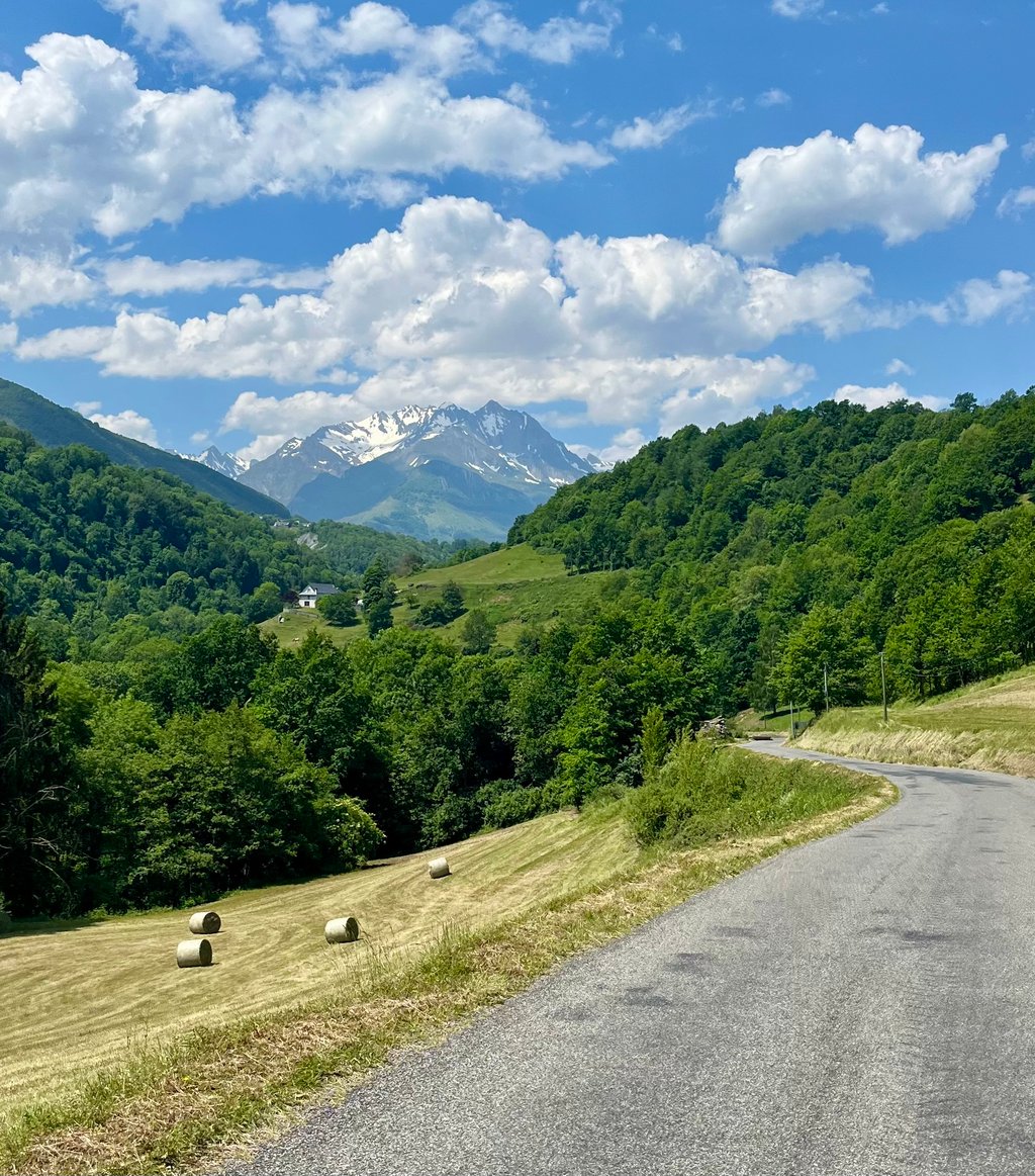
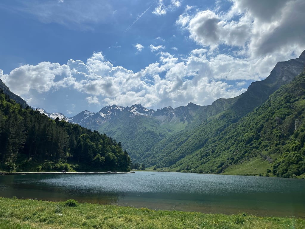
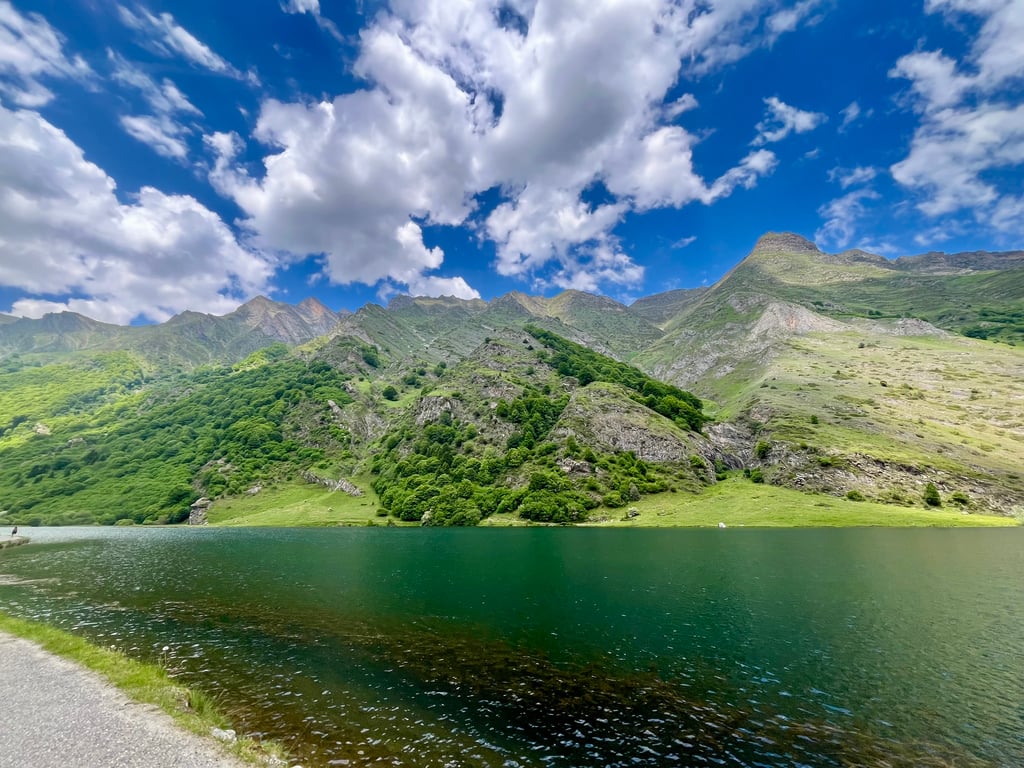
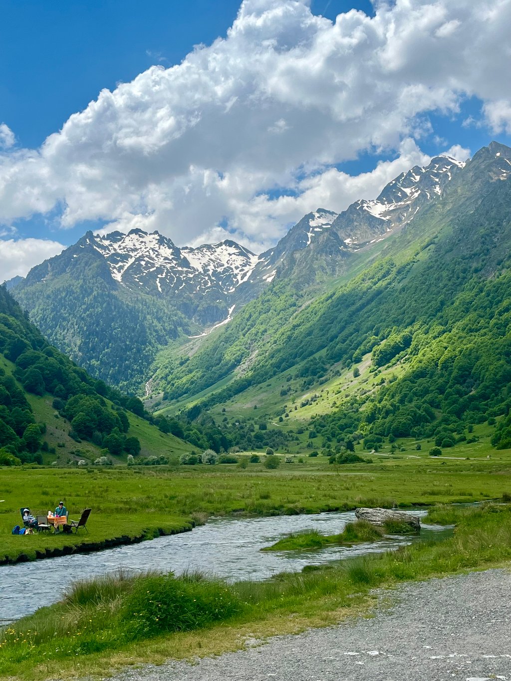
Lac d'Estaing from Argelès-Gazost is a climb in the region Hautes-Pyrénées. It is 10.8 mi long and bridges 2667 ft of vertical ascent with an average gradient of 4.7%, resulting in a difficulty score of 526. The top of the ascent is located at 3842 ft above sea level. Climbfinder users shared 4 reviews of this climb and uploaded 9 photos.
Road names: Route du Lac d'Estaing & D 103
4.0 by Sparti54This is an automatic translation, the original language is: Polish.An idyllic driveway with a surprise at the very end, I recommend driving it up through Saint-Savin then there is less traffic and more shade, which is especially important on a hot day.... read more

Welcome! Please activate your account if you would like to share something. Look for the verification email in your inbox.
If you want to upload your photos, you need to create an account. It only takes 1 minute and it's completely free.
An idyllic driveway with a surprise at the very end, I recommend driving it up through Saint-Savin then there is less traffic and more shade, which is especially important on a hot day.
Sielankowy podjazd z niespodzianka na samym końcu, polecam podjechać go przez Saint-Savin wtedy ruch uliczny jest mniejszy i a więcej jest cienia, co szczególnie w upalny dzień ma znaczenie.
This climb does deserve a slightly higher rating. Admittedly, the first stretch is a bit crowded and a steep start. But the closer you get to Estaing, the nicer the ride becomes. You ride along a small river, see beautiful things and it is (except for the beginning) nowhere tough.
Tip: take the over-hard climb with the MTB or Gravelbike. You then turn left up the mountain at Reservoir de Bernata. It is an MTB route, lots of boulders. But doable on your gravel bike. The views along the way and especially on top are stunning (segment on Strava is called 'La Montée 13km' and is an HC climb). Then the descent towards Estaing is super, a nice single track that doesn't get tricky anywhere and ends on a fast gravel section and lovely quiet tarmac road (you then end up in the hamlet of Sireix).
Deze klim verdient wel een iets hogere waardering. Toegegeven, het eerste stuk is wat druk en een steil begin. Maar hoe dichter bij Estaing, hoe mooier de rit wordt. Je rijdt langs een riviertje, ziet mooie dingen en het is (muv het begin) nergens zwaar.
Tip: neem met de MTB of Gravelbike de overharde klim erbij. Je gaat dan bij Reservoir de Bernata linksaf de berg op. Het is een MTB route, veel keien. Maar wel te doen op je gravelbike. Het uitzicht onderweg en vooral bovenop is prachtig (segment op Strava heet 'La Montée 13km' en is een HC klim). Vervolgens is de afdaling richting Estaing super, een mooie single track die nergens lastig wordt en uitkomt op een snel gravelstuk en heerlijk rustige asfaltweg (je komt dan uit in het gehuchtje Sireix).
Nice not too difficult ride from Argeles Gazost to the lac. The first few kilometres on the main road to the Aubisque/Soulor, but via Arras-en-Lavedam you leave the crowds and ride on a fine road (with some gravel at times) towards the lake. Good to combine with the Col de Borderes, and as Patrick points out just a fine warm-up for all the tougher cols in the area.
Oh yes, at the lake there is a stall where you can get a delicious piece of cake (see the 2nd photo), highly recommended!
Leuke niet al te zware tocht vanuit Argeles Gazost naar het lac. De eerste kilometers even op de doorgaande weg naar de Aubisque/Soulor, maar via Arras-en-Lavedam verlaat je de drukte en rijd je over een prima weg (met soms wat grind) richting het meer. Goed te combineren met de Col de Borderes, en zoals Patrick al aangeeft gewoon een fijne opwarmer voor alle zwaardere cols in de omgeving.
O ja, bij het meer staat een kraampje waar je een heerlijk stuk taart kan halen (zie de 2e foto), aanrader !!
Climbing to the beautifully situated Lac d'Estaing is great to combine with the Col de Bordères, which is almost on the same route (see CF).
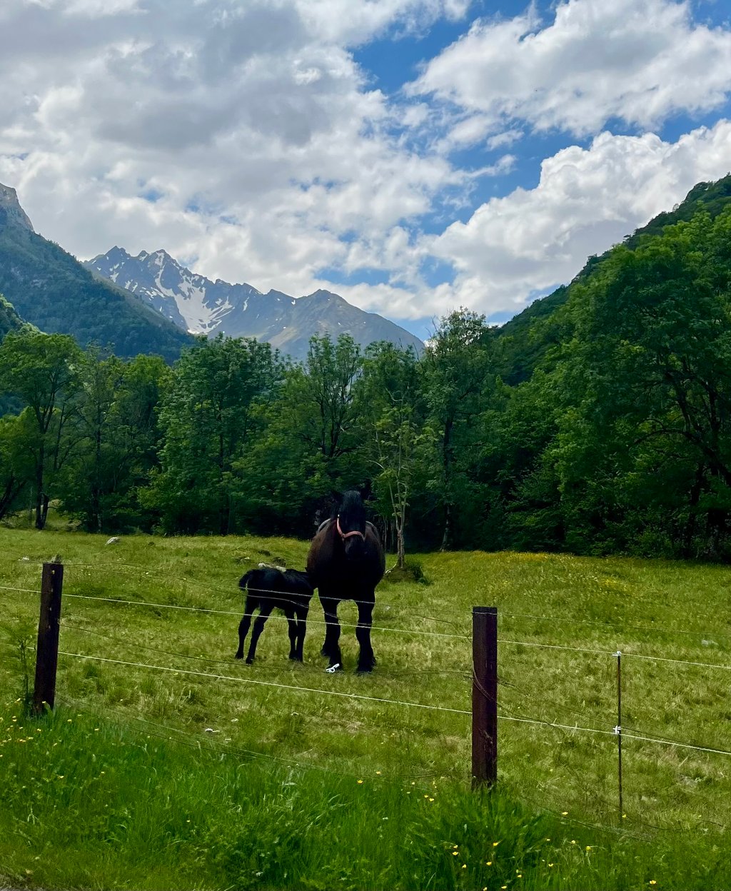
To climb out of the starting town of Argelès Gazost, it is a bit of a pedal push on the at times busy road towards Aubisque/Soulor, which you can leave on the left in the first village of Arras-en-Lavedam. Signposts to Lac d'Estaing indicate exit after which you first cycle through the small streets of the village centre followed by a short descent to the river (La Gave d'Azur). After the bridge over it, there is a steep climb but from then on the narrow low-traffic road between the forests follows the river gently upstream. In Estaing, you can immediately turn right for the Col de Bordères but the beautiful lake surrounded by mountain peaks is a further four kilometres or so of gentle climbing. Along the tourist (catering) shore lots of sunbathers, hikers and some cows/horses running loose.
Ideal warm-up for firmer and better-known cycling on the tour classics in the area.
Klim naar het mooi gelegen Lac d'Estaing is prima te combineren met de nagenoeg op dezelfde route gelegen col de Bordères (zie CF).
Om vertrekstadje Argelès Gazost uit te klimmen is het even op de trappers duwen op de bij momenten drukke weg richting Aubisque/Soulor dewelke je in het eerste dorpje Arras-en-Lavedam links kan verlaten. Wegwijzer naar Lac d'Estaing geeft afslag aan waarna je eerst door de kleine straatjes van de dorpskern fietst gevolgd door een korte afdaling naar de rivier (La Gave d'Azur). Na de brug erover is het even stevig klimwerk maar vanaf dan volgt de smalle verkeersarme weg tussen de bossen de rivier zacht stijgend stroomopwaarts. In Estaing kan je direct rechts afdraaien voor de Col de Bordères maar het prachtige meer omgeven door bergtoppen is nog even een viertal kilometer zacht klimmend verder. Langs de toeristische (horeca) oever veel zonnekloppers,wandelaars en enkele loslopende koeien/paarden .
Ideale opwarmer voor steviger en bekender fietswerk op de tour klassiekers in de omgeving.
| 5 mph | 02:09:56 |
| 7 mph | 01:31:59 |
| 9 mph | 01:11:41 |
| 12 mph | 00:53:51 |
This page is better in the app