View on map
© MapLibre | OpenStreetMap contributors
1%
2%
4%
6%
8%
10%
12%
15%
20%

La Fruitière from Pierrefitte-Nestalas

4.0
1 review/story | Elevation profile | 1 photo
In some places the road surface of this climb is bad, but it can be ridden with a road bike.
Tips nearby
La Fruitière from Pierrefitte-Nestalas
transparant thumb
transparant thumb
transparant thumb
transparant thumb
transparant thumb
transparant thumb
transparant thumb
Your achievable time
Calculating based on your best performances...
Relaxed
Maximum
W/kg
W/kg
W/kg
Analyze your climbing performance
Detailed insight into your climbing performance & automatically check off climbs
Based on your best performances.
Your best attempt:
Number of attempts:
Elevation profile La Fruitière from Pierrefitte-Nestalas
paved
bad road

Statistics

Difficulty points 673
Length 10.2 mi
Average gradient 5.3%
Steepest segment 20.4%
Total ascent 2887 ft

Short recap

Beautiful scenery
9 hairpin turns
Bad road
#87 toughest climb of Occitania
#89 most elevation gain of Occitania
#98 longest climb of Occitania
Feedback about this climb?
Show climbs nearby Export to GPS device

La Fruitière from Pierrefitte-Nestalas is a climb in the region Hautes-Pyrénées. It is 10.2 mi long and bridges 2887 ft of vertical ascent with an average gradient of 5.3%, resulting in a difficulty score of 673. The top of the ascent is located at 4478 ft above sea level. Climbfinder users shared 1 review/story of this climb and uploaded 1 photo.

Road names: Route de Pierrefitte & Route du Pont d'Espagne
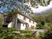
4.0 by DikkeTInus
This is an automatic translation, the original language is: Dutch.
Caught up on the descent from Pont d'Espagne. What a REALLY bad tarmac, but oh what beautiful views once you get to the top. And at the refuge really ate the tastiest and biggest point of berry pie (local speciality) of our two weeks in the Pyrenees. Climbing on this tarmac is not an issue, the gradients are. But descending is a real disaster, so take your time and watch out! The photo shows the end point, we had walked up the footpath for a bit after our ride.... read more

Photos (1)

La Fruitière from Pierrefitte-Nestalas
transparant thumb
transparant thumb
transparant thumb
transparant thumb
transparant thumb

Your uploads (max 4)

Welcome! Please activate your account if you would like to share something. Look for the verification email in your inbox.

If you want to upload your photos, you need to create an account. It only takes 1 minute and it's completely free.

  • Receive free climbfinder goodies for your reviews & photos.
  • Create a bucket list and check off conquered climbs.
  • Add missing climbs.
Continue with GoogleContinue with Google Continue with FacebookContinue with Facebook Continue with AppleContinue with Apple Sign up with email
By signing up you agree to our terms of service and confirm that you have read our privacy & content policy.

Reviews (1)

5.0
4.0
3.0
2.0
1.0
DikkeTInus
1 y 4.0
This is an automatic translation, the original language is: Dutch. Show original

Caught up on the descent from Pont d'Espagne. What a REALLY bad tarmac, but oh what beautiful views once you get to the top. And at the refuge really ate the tastiest and biggest point of berry pie (local speciality) of our two weeks in the Pyrenees.

Climbing on this tarmac is not an issue, the gradients are. But descending is a real disaster, so take your time and watch out!

The photo shows the end point, we had walked up the footpath for a bit after our ride.

Meegepakt op de afdaling van Pont d'Espagne. Wat een VRESELIJK slecht asfalt, maar oh wat een mooi uitzicht als je eenmaal boven bent. En bij de refuge echt de lekkerste en grootste punt bessentaart (lokale specialiteit) gegeten van onze twee weken in de Pyreneeën.

Klimmen op dit asfalt is geen issue, de stijgingspercentages wel. De percentages die op deze site worden gemeld kloppen niet. Ik heb het dan over het laatste stuk (10-12% volgens de grafiek). 10% is zeg maar het minimum, je rijdt hele stukken 16 en hij knalt een paar keer naar 20%. Het dalen is dan ook erg link door het asfalt en de enorme snelheid die je genereert op die steile stukken. Neem dus je tijd en pas goed op. De weg is ook smal en af en toe komt er een auto omhoog.

De foto toont het eindpunt, we waren een stukje het wandelpad opgelopen na onze rit.

La Fruitière from Pierrefitte-Nestalas
Dashboard

Climbing times

5 mph 02:03:37
7 mph 01:27:31
9 mph 01:08:12
12 mph 00:51:14

Road surface condition

0% 0% 0%
Based on 0 votes
Share your knowledge. What was the road condition during your ascent?

Traffic

0% 0% 0%
Based on 0 votes
Your experience counts. How much traffic did you encounter during the climb?

Frequently Asked Questions

You don't need special gearing for La Fruitière from Pierrefitte-Nestalas. The slope isn't long or steep enough to require much shifting down. You can conquer this climb on power alone. However, a compact gearing system with a smallest front chainring of 34 and largest rear sprocket of 28 or 30 is always nice if you enjoy cycling uphill. This helps maintain a smooth cadence.

La Fruitière from Pierrefitte-Nestalas is a first-category climb: long and tough. Do not underestimate this climb. Many famous Tour de France cols fall into this category. Prepare for a long, challenging ride. Only well-trained riders will reach the top smoothly. Make sure you have a road bike with climbing gears and enough training; otherwise, it will be a struggle.

La Fruitière from Pierrefitte-Nestalas is 10.2 mi long.

The average gradient of La Fruitière from Pierrefitte-Nestalas is 5.3%.

La Fruitière from Pierrefitte-Nestalas has a steepest segment with an average gradient of 20.4%.

The summit of La Fruitière from Pierrefitte-Nestalas is at 4478 ft.

At a slow pace of 5 mph, it takes about 02:03:37 to climb La Fruitière from Pierrefitte-Nestalas. At 7 mph the time is 01:27:31, and at 9 mph 01:08:12. For the fastest cyclists, 00:51:14 is an achievable time.

La Fruitière from Pierrefitte-Nestalas is located in the region Hautes-Pyrénées in France.

This page is better in the app

Climbfinder app
Climbfinder
(Free)
Open