Hallembaye from Eben is a climb in the region Haspengouw. It is 0.8 mi long and bridges 207 ft of vertical ascent with an average gradient of 5.2%, resulting in a difficulty score of 34. The top of the ascent is located at 433 ft above sea level. Climbfinder users shared 12 reviews of this climb and uploaded 7 photos.
Road names: Route de Visé & Rue Sous le Boeuf (N671)
2.0 by JurneSleddensThis is an automatic translation, the original language is: Dutch.The only reason I include this climb in my'n route is the wonderfully fast descent. This one is short but a bit steep, so speeds near/over 90 are possible. The climb itself is an N-road with a fair amount of traffic, the road surface is not too good on the side and the views are not there.... read more
Welcome! Please activate your account if you would like to share something. Look for the verification email in your inbox.
If you want to upload your photos, you need to create an account. It only takes 1 minute and it's completely free.
The only reason I include this climb in my'n route is the wonderfully fast descent. This one is short but a bit steep, so speeds near/over 90 are possible. The climb itself is an N-road with a fair amount of traffic, the road surface is not too good on the side and the views are not there.
De enige reden dat ik deze klim meeneem in m'n route is de heerlijk snelle afdaling. Deze is kort maar een stukje steil, dus snelheden tegen/over de 90 zijn mogelijk. De beklimming zelf is een N-weg met redelijk wat verkeer, het wegdek is niet al te goed aan de zijkant en het uitzicht is er niet.
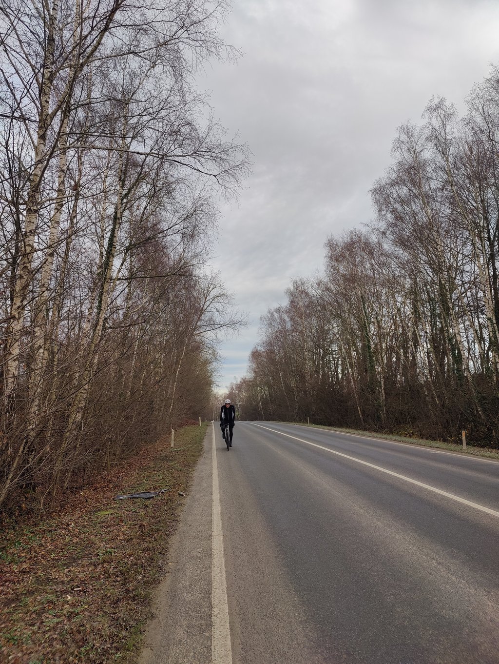
Gradual climb from Eben with traffic on the road from the beginning. The profile rises gently and constantly with no real outliers.
Mainly a practical connection, rather functional than pleasant to ride.
Geleidelijke klim vanuit Eben met vanaf het begin verkeer op de weg. Het profiel loopt rustig en constant omhoog zonder echte uitschieters.
Vooral een praktische verbinding, eerder functioneel dan aangenaam om te rijden.
Easy side of the Hallembaye with a fast straightforward descent on the other side. Gradual climb through the forest.
Makkelijke kant van de Hallembaye met een snelle rechttoe rechtaan afdaling aan de andere kant. Geleidelijke klim door het bos.
Easier side of the Hallembaye. The ascent from the north is easier than the southern side. There is quite a lot of freight traffic and the tarmac is not good. As a shortcut to Liège or the Ardennes, however, a good warm-up.
Eenvoudigere kant van de Hallembaye. De beklimming vanuit het noorden is makkelijker dan de zuidelijke kant. Er rijdt vrij veel vrachtverkeer en het asfalt is niet goed. Als doorsteek naar Luik of de Ardennen echter een goede opwarmer.
0/5 Awful. Even on a Saturday morning unpleasantly busy with fast-moving traffic. The right side of the road is also full of potholes which basically forces you to drive more towards the middle of the lane. You are just putting on overtaking traffic, as you have plenty of them overtaking just before the summit while they can't see the opposite direction as a result. Luckily the gradient drops more so it's all easy, but that ks also the only thing. Unfortunately few alternatives if you want to get from A to B for this road.
0/5 Vreselijk. Zelfs op een zaterdagochtend al onprettig druk met snel verkeer. De rechterkant van de weg zit ook vol met gaten waardoor je eigenlijk gedwongen wordt meer naar het midden van de rijbaan te rijden. Je bent alleen maar bezig met op inhalend verkeer te zetten, want je hebt er genoeg bij vlak voor de top gaan inhalen terwijl ze daardoor de tegenrichting niet kunnenzien. Gelukkig vallen de steigingspercentages meer waardoor het makkelijk gaat allemaal, maar dat ks ook het enige. Helaas weinig alternatieven als je van naar A naar B wilt voor deze weg.
Nice climb in not so nice surroundings. Especially on weekdays, it is giga crowded with (freight) traffic. This side is easier as the climb from the south. The first 1000 metres go up at a fairly tight gradient. Only the last bit to the top the gradient rises a bit more.
Leuke klim in een minder mooie omgeving. Zeker op werkdagen is het gigadruk met (vracht)verkeer. Deze zijde is gemakkelijker als de klim vanuit het zuiden. De eerste 1000 meter gaat het met een redelijk strak stijgingspercentage omhoog. Pas het laatste stukje tot de top loopt het stijgingspercentage nog wat op.
Most has already been said about this. The road quality in the lace is very poor, so you still have to drive partly on the road. Cars's do drive 90 km/h here and it did not feel very safe. Unfortunately, there is not really an alternative if you want to cross the canal. Also an unpleasant bridge there by the way. There is a fine parallel path on the bridge, but it is not connected to the road. Typical Walloon. The idea is there but the elaboration is lacking.
Het meeste is hier al over gezegd. De wegkwaliteit in het kantje is erg slecht, waardoor je toch deels op de rijbaan moet rijden. Het leuke is wel dat je hard naar beneden kunt dalen. Auto's rijden hier wel 90 km/u en erg veilig voelde het niet. Helaas is er niet echt een alternatief als je het kanaal over wilt steken. Ook een onprettige brug trouwens daar. Er is een prima parallel pad op de brug, maar die is niet aangesloten op de weg. Typisch Waals. Het idee is er wel maar de uitwerking ontbreekt.
A somewhat difficult climb to judge. On the one hand it's a reasonable runner, the road winds up slightly in a wooded area and at the start you can see the valley disappearing below you on the right. Seen in this way there is little wrong with it. however, the asphalt is pretty bad on the sides so that in many places you actually want to ride a meter from the side. The latter is not so wise because of the other traffic in combination with the relatively narrow road. Outside the weekend (when there is no truck traffic) certainly not recommended or you have the bad asphalt well can handle and as right as possible cycling. After the top, the road drops almost straight down and you can descend very hard (here, however, reasonable to good asphalt).
Only if there is no other option, but that is quite difficult with this climb because it is an excellent connecting road.
Een wat lastig te beoordelen klim. Enerzijds is het een redelijke loper, de weg slingert enigszins omhoog in een bosrijke omgeving en in het begin zie je rechts het dal onder je verdwijnen. Zo gezien is er weinig mis mee. het asfalt is echter aan de zijkanten behoorlijk slecht waardoor je op veel plaatsen eigenlijk een meter vanaf de kant wilt rijden. Dat laatste is alleen niet zo verstandig vanwege het overige verkeer i.c.m. de relatief smalle weg. Buiten het weekend (dan is er geen vrachtverkeer) zeker niet aan te raden of je moet het slechte asfalt goed aankunnen en zo rechts mogelijk blijven fietsen. Na de top knalt de weg vrijwel recht omlaag en kan je dus loeihard afdalen (hier wel redelijk tot goed asfalt).
Alleen als er geen andere optie is dus, maar dat is met deze klim behoorlijk moeilijk want het is een uitstekende verbindingsweg.
The least steep side of the Halembaye, not very nice climb with lots of traffic including trucks. The descent is zoef zoef down bang, straight forward, steep without curve. So the high speed can be quite dangerous by wind and trucks.
De minst steile kant van de Halembaye, niet erg leuke klim waar nogal veel verkeer incl vrachtverkeer over heen kan razen. De afdaling is zoef zoef naar beneden knallen, recht toe recht aan, steil zonder bocht. Dus kan door de hoge snelheid best gevaarlijk worden door wind en vrachtwagens.
The easy side of the famous Halembaye. Not really recommended in terms of slope or landscape. Very busy connecting road.
De makkelijke kant van de beroemde Halembaye. Niet echt een aanrader qua helling of landschap. Zeer drukke verbindingsweg.
This is one to do on the weekend, otherwise the cars'll fly around your ears. If you go on the weekend you might see a car or two and can do the steep, straight descent on perfect tarmac as quickly and safely as you like. This side is a lot less strenuous than the other side. The Hallembaye is a real icon in the region, whether you do it on this side, or on the heavy side.
Dit is eentje om in het weekend te doen, anders vliegen de auto's je rond de oren. Wanneer je in het weekend gaat zie je misschien een auto of twee en kan de steile, rechte afdaling op perfect asfalt zo snel en 'veilig' doen als je zelf wil. Deze kant is een stuk minder zwaar dan de andere kant. De Hallembaye is een echt icoon in de streek, of je hem nu langs deze, of langs de zware kant doet.
Even climb, much easier than the other side. If you're at the top you can do at high speed (big road, steep, straight) the Hallembaye descend. Unfortunately, many cars and trucks on this road hard to drive.
Gelijkmatige klim, stuk makkelijker dan de andere kant. Als je boven bent kun je wel op hoge snelheid (grote weg, steil, rechtdoor) de Hallembaye afdalen. Helaas wel veel auto's en vrachtauto's die op deze weg hard rijden.
| 5 mph | 00:09:08 |
| 7 mph | 00:06:28 |
| 9 mph | 00:05:02 |
| 12 mph | 00:03:47 |
This page is better in the app