View on map
© MapLibre | OpenStreetMap contributors
1%
2%
4%
6%
8%
10%
12%
15%
20%

Haerebierg

4.0
3 reviews | Elevation profile | 1 photo
Tips nearby
Haerebierg
transparant thumb
transparant thumb
transparant thumb
transparant thumb
transparant thumb
transparant thumb
transparant thumb
Your achievable time
Calculating based on your best performances...
Relaxed
Maximum
W/kg
W/kg
W/kg
Analyze your climbing performance
Detailed insight into your climbing performance & automatically check off climbs
Based on your best performances.
Your best attempt:
Number of attempts:
Elevation profile Haerebierg

Statistics

Difficulty points 186
Length 0.7 mi
Average gradient 12%
Steepest segment 20.6%
Total ascent 443 ft

Short recap

Beautiful scenery
Hidden gem
#100 toughest climb of Ardennes
#67 most elevation gain of Nordstad
#23 average steepest climb of Ardennes
Feedback about this climb?
Show climbs nearby Export to GPS device

Haerebierg is a climb in the region Nordstad. It is 0.7 mi long and bridges 443 ft of vertical ascent with an average gradient of 12%, resulting in a difficulty score of 186. The top of the ascent is located at 1165 ft above sea level. Climbfinder users shared 3 reviews of this climb and uploaded 1 photo.

Road name: Haerebiergstross
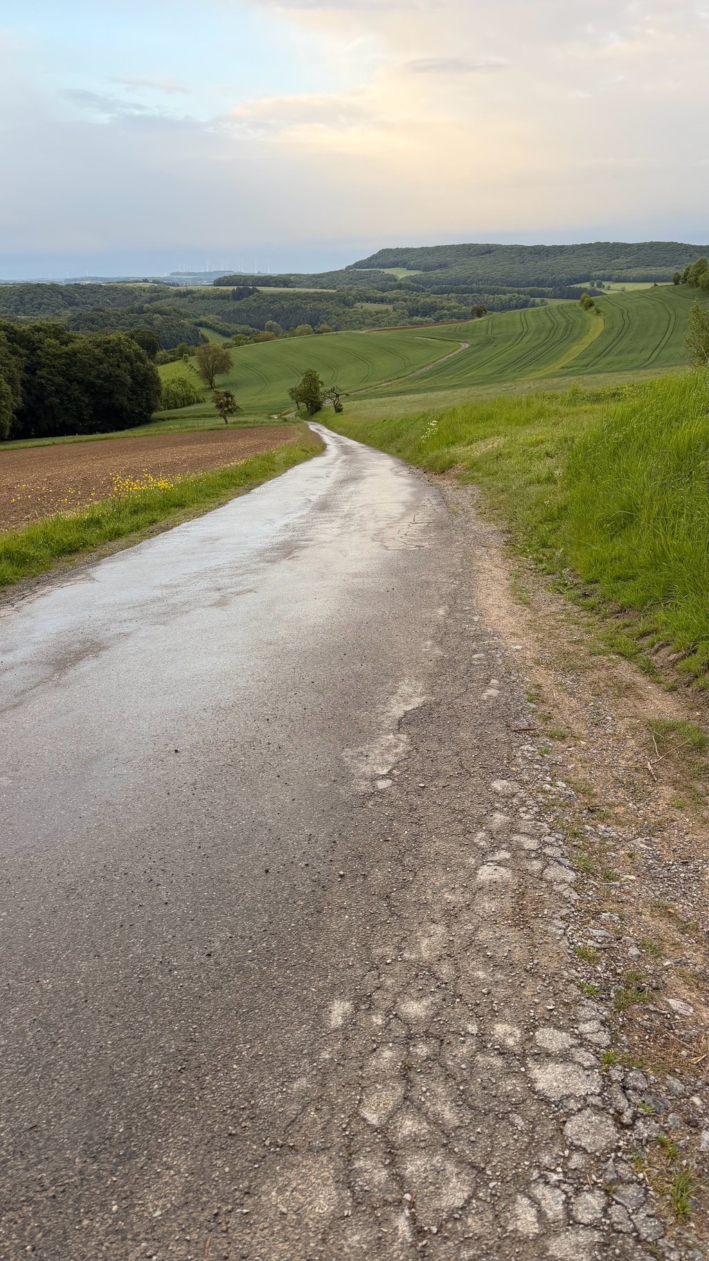
This is an automatic translation, the original language is: Dutch.
Very fine climb. It starts the Eersel meters immediately pitting. After the Bo then opens the landscape itself and king you den nice view of the Hill country. At the end you can keep left to the top, where the asphalt turns into an unpaved path. Possibly continue on foot for a nice view of Diekirch. The ascent from Diekirch is also worthwhile.... read more

Photos (1)

Haerebierg
transparant thumb
transparant thumb
transparant thumb
transparant thumb
transparant thumb

Your uploads (max 4)

Welcome! Please activate your account if you would like to share something. Look for the verification email in your inbox.

If you want to upload your photos, you need to create an account. It only takes 1 minute and it's completely free.

  • Receive free climbfinder goodies for your reviews & photos.
  • Create a bucket list and check off conquered climbs.
  • Add missing climbs.
Continue with GoogleContinue with Google Continue with FacebookContinue with Facebook Continue with AppleContinue with Apple Sign up with email
By signing up you agree to our terms of service and confirm that you have read our privacy & content policy.

Reviews (3)

5.0
4.0
3.0
2.0
1.0
koenvanholten
2 w 4.0 via the Climbfinder app
This is an automatic translation, the original language is: Dutch. Show original

Very fine climb. It starts the Eersel meters immediately pitting. After the Bo then opens the landscape itself and king you den nice view of the Hill country. At the end you can keep left to the top, where the asphalt turns into an unpaved path. Possibly continue on foot for a nice view of Diekirch. The ascent from Diekirch is also worthwhile.

Hele fine klim. Het begins de Eersel meters meteen pitting. Na de Bo then opens het landschap zich en king je den mooi zicht op het Heuvel land. Aan het einde kun je links aanhouden naar de top, waar het asfalt overgaat in een onverhard pad. Eventueel te voet verder voor mooi zicht op Diekirch. De beklimming vanaf Diekirch is ook de moeite waard.

Haerebierg
Dashboard
MaxS4
1 y 4.0

This is a tough climb. Because of the many small bends, it is hard to pace and you don't see the road. It is quite steep and relentless. While there are no nice views, it is in the midst of the nature and very calm.

Dashboard
Mauricev
4 y 4.0
This is an automatic translation, the original language is: Dutch. Show original

The numbers don't lie. This is a hell of a climb. Road surface is in reasonable condition. I did not encounter any traffic. I think it was even forbidden for cars. Do not expect beautiful views. It is mainly forests what you see.

De cijfers liegen er niet om. Dit is een vreselijk zware klim. Wegdek is in redelijke staat. Verkeer kwam ik er niet tegen. Volgens mij was het zelfs ook verboden voor auto’s. Verwacht geen mooie uitzichten. Het is vooral bossen wat je ziet.

Dashboard

Climbing times

5 mph 00:08:24
7 mph 00:05:57
9 mph 00:04:38
12 mph 00:03:29

Road surface condition

0% 100% 0%
Based on 2 votes
Share your knowledge. What was the road condition during your ascent?

Traffic

100% 0% 0%
Based on 2 votes
Your experience counts. How much traffic did you encounter during the climb?

Frequently Asked Questions

Haerebierg can be cycled from 2 sides. Haerebierg from Bastendorf is the most popular side, but the summit can also be reached via Haerebierg from Diekirch.

Haerebierg is a challenging ascent. For this type of climbing, we recommend mountain gearing, specifically a compact system. This means a small front chainring of 34 teeth, combined with a rear cassette where, depending on your level, strength, and experience, you choose a sprocket with 30, 32, or even 34 teeth. Remember that a smooth cadence is always more efficient!

Haerebierg is a 3rd-category climb. Almost anyone can handle this climb, as long as you have a bike with climbing gears. If you have little training, you will probably need to shift down significantly. For experienced riders, Haerebierg is not a problem.

Haerebierg is 0.7 mi long.

The average gradient of Haerebierg is 12%.

Haerebierg has a steepest segment with an average gradient of 20.6%.

The summit of Haerebierg is at 1165 ft.

At a slow pace of 5 mph, it takes about 00:08:24 to climb Haerebierg. At 7 mph the time is 00:05:57, and at 9 mph 00:04:38. For the fastest cyclists, 00:03:29 is an achievable time.

Haerebierg is located in the region Nordstad in Luxembourg.

This page is better in the app

Climbfinder app
Climbfinder
(Free)
Open