View on map
© MapLibre | OpenStreetMap contributors
1%
2%
4%
6%
8%
10%
12%
15%
20%

Col du Télégraphe from Valloire

2.7
7 reviews | Elevation profile | 8 photos
Tips nearby
Col du Télégraphe from Valloire
Your achievable time
Calculating based on your best performances...
Relaxed
Maximum
W/kg
W/kg
W/kg
Analyze your climbing performance
Detailed insight into your climbing performance & automatically check off climbs
Based on your best performances.
Your best attempt:
Number of attempts:
Elevation profile Col du Télégraphe from Valloire

Statistics

Difficulty points 74
Length 2.9 mi
Average gradient 3.4%
Steepest segment 8.7%
Total ascent 515 ft

Short recap

Famous climb
#90 toughest climb of La Maurienne
#87 most elevation gain of La Maurienne
#68 longest climb of La Maurienne
#90 average steepest climb of La Maurienne
Feedback about this climb?
Show climbs nearby Export to GPS device

Col du Télégraphe from Valloire is a climb in the region La Maurienne. It is 2.9 mi long and bridges 515 ft of vertical ascent with an average gradient of 3.4%, resulting in a difficulty score of 74. The top of the ascent is located at 5138 ft above sea level. Climbfinder users shared 7 reviews of this climb and uploaded 8 photos.

Road names: D 902 & Chemin de la Gardjelerie

2.0 by Cromagnon
This is an automatic translation, the original language is: French.
The easiest pass in the Alps? Of course, that's not why we're here.... read more

Photos (8)

Col du Télégraphe from Valloire
transparant thumb
transparant thumb
transparant thumb
transparant thumb

Your uploads (max 4)

Welcome! Please activate your account if you would like to share something. Look for the verification email in your inbox.

If you want to upload your photos, you need to create an account. It only takes 1 minute and it's completely free.

  • Receive free climbfinder goodies for your reviews & photos.
  • Create a bucket list and check off conquered climbs.
  • Add missing climbs.
Continue with GoogleContinue with Google Continue with FacebookContinue with Facebook Continue with AppleContinue with Apple Sign up with email
By signing up you agree to our terms of service and confirm that you have read our privacy & content policy.

Reviews (7)

5.0
4.0
3.0
2.0
1.0
Cromagnon
9 Mo 2.0
This is an automatic translation, the original language is: French. Show original

The easiest pass in the Alps?
Of course, that's not why we're here.

Le col le plus facile des Alpes ?
Bien entendu, ce n’est pas pour ce versant que l’on est là.

Col du Télégraphe from Valloire
Dashboard
YehoSer
9 Mo 2.0 00:11:42 (14.9 mph)
This is an automatic translation, the original language is: French. Show original

There's not much point in going back to Saint Michel de Maurienne if you've done the Galibier.

Pas de grand intérêt si ce n'est de retourner à Saint Michel de Maurienne quand on a fait le Galibier

Dashboard
WouterDK
11 Mo 3.0
This is an automatic translation, the original language is: Dutch. Show original

Easy runner, but heavy traffic at times. Beautiful views, but otherwise nothing special about it.

Gemakkelijke loper, maar soms veel verkeer. Mooie vergezichten, maar voor de rest niets speciaal aan.

Dashboard
JohanL38
1 y 5.0
This is an automatic translation, the original language is: French. Show original

Take the 2009 route from St Michel de Maurienne up to the Col du Galibier.

Monter en 2009 partis de St Michel de Maurienne pour continuer jusqu au col du Galibier.

Dashboard
patrickbaert
2 y 3.0
This is an automatic translation, the original language is: Dutch. Show original

This side of the col du Télégraph is a lot shorter and easier than the Maurienne valley side.
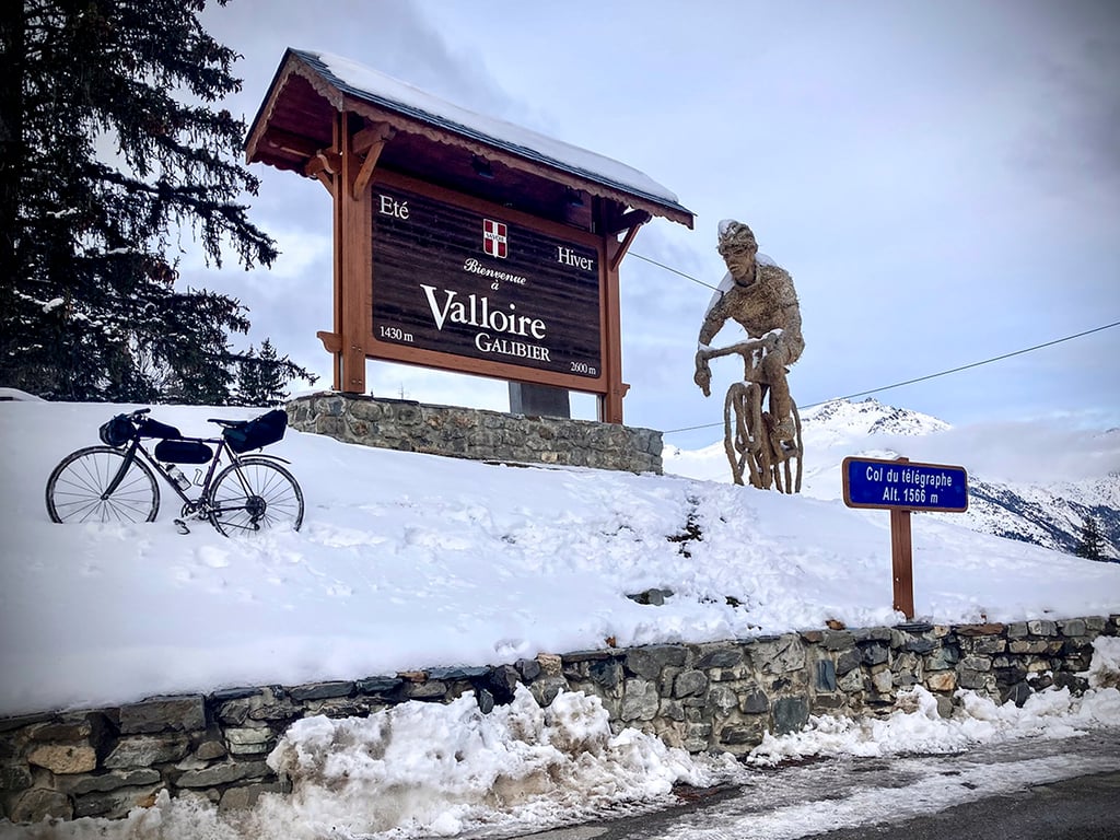
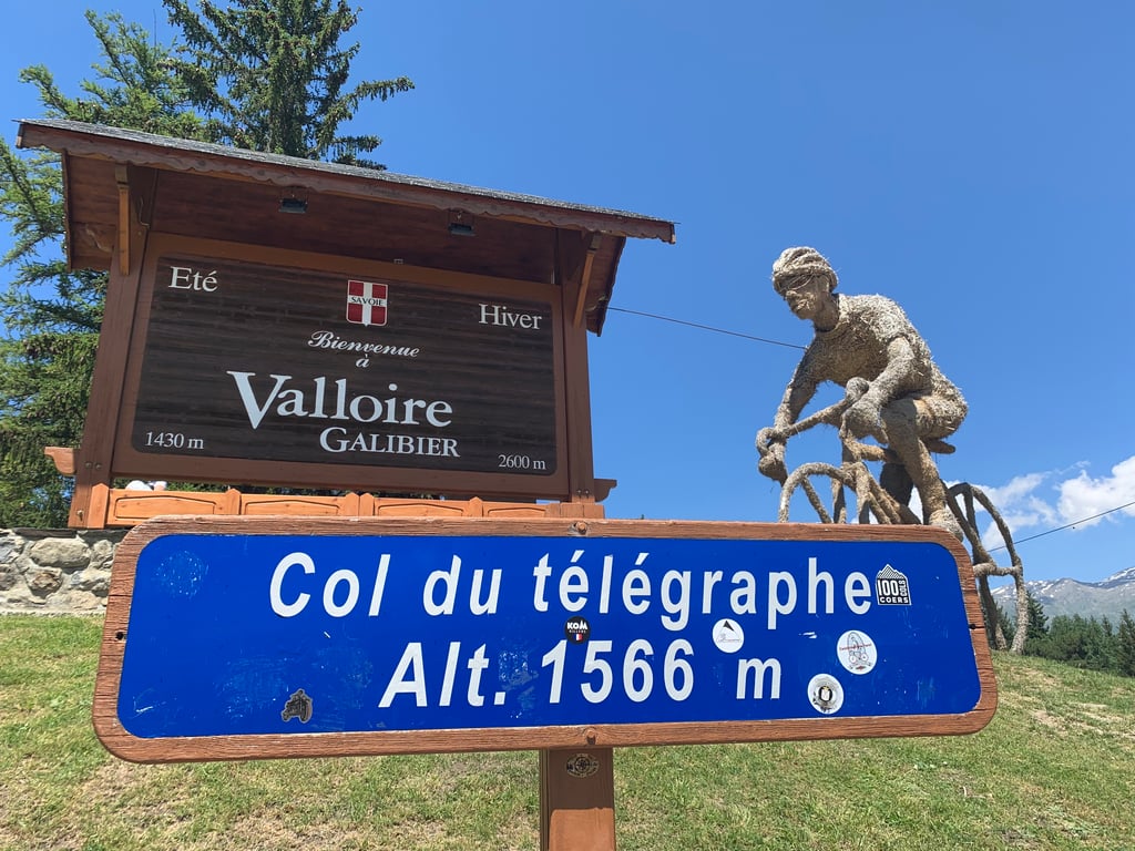
A little push on the pedals as you leave Valloire, before cycling false flat via gently turning wide road to the summit plateau with catering facilities and the famous straw bike sculpture.
There is busy traffic at times, though.
If you have crawled up the Galibier before, this feels like "flat"!

Deze kant van de col du Télégraph is een pak korter en gemakkelijker dan de Maurienne dal zijde.
Even op de trappers duwen bij het verlaten van Valloire, om dan vals plat via licht draaiende brede weg naar het top plateau met horeca en het bekende strooien fietsbeeld te fietsen.
Er is soms wel druk verkeer.
Als je voordien de Galibier hebt opgekropen voelt dit als "vlak" aan!

Col du Télégraphe from Valloire
Dashboard
Franck_Pastor
3 y 2.0
This is an automatic translation, the original language is: French. Show original

A short, rolling climb on a wide, busy road. This is the only way to get back down to the Maurienne from Valloire, but it is the only way to get there.

Montée courte et roulante sur une route large et fréquentée. C'est la seule façon de redescendre en Maurienne à partir de Valloire, mais c'est bien son seul intérêt.

Dashboard
EddyS
3 y 2.0
This is an automatic translation, the original language is: Dutch. Show original

Short climb that only hurts when you have just climbed the Galibier. Has nothing special to offer.

Korte klim die alleen pijn doet wanneer je net de galibier beklommen hebt. Heeft niets speciaal te bieden.

Dashboard

Climbing times

5 mph 00:35:08
7 mph 00:24:52
9 mph 00:19:23
12 mph 00:14:34

Road surface condition

100% 0% 0%
Based on 7 votes
Share your knowledge. What was the road condition during your ascent?

Traffic

14% 57% 29%
Based on 7 votes
Your experience counts. How much traffic did you encounter during the climb?

Frequently Asked Questions

Col du Télégraphe can be cycled from 2 sides. Col du Télégraphe from Saint-Michel-de-Maurienne is the most popular side, but the summit can also be reached via Col du Télégraphe from Valloire.

You don't need special gearing for Col du Télégraphe from Valloire. The slope isn't long or steep enough to require much shifting down. You can conquer this climb on power alone. However, a compact gearing system with a smallest front chainring of 34 and largest rear sprocket of 28 or 30 is always nice if you enjoy cycling uphill. This helps maintain a smooth cadence.

Col du Télégraphe from Valloire falls into the 5th category. With good fitness, you can ride it up with speed and power. If you have less training, shift down and climb smoothly.

Col du Télégraphe from Valloire is 2.9 mi long.

The average gradient of Col du Télégraphe from Valloire is 3.4%.

Col du Télégraphe from Valloire has a steepest segment with an average gradient of 8.7%.

The summit of Col du Télégraphe from Valloire is at 5138 ft.

At a slow pace of 5 mph, it takes about 00:35:08 to climb Col du Télégraphe from Valloire. At 7 mph the time is 00:24:52, and at 9 mph 00:19:23. For the fastest cyclists, 00:14:34 is an achievable time.

Col du Télégraphe from Valloire is located in the region Savoie in France.

This page is better in the app

Climbfinder app
Climbfinder
(Free)
Open