View on map
© MapLibre | OpenStreetMap contributors
1%
2%
4%
6%
8%
10%
12%
15%
20%

Col de Veaux from Le Toulourenc

3.5
2 reviews | Elevation profile | 3 photos
Tips nearby
Col de Veaux from Le Toulourenc
transparant thumb
transparant thumb
transparant thumb
transparant thumb
transparant thumb
Your achievable time
Calculating based on your best performances...
Relaxed
Maximum
W/kg
W/kg
W/kg
Analyze your climbing performance
Detailed insight into your climbing performance & automatically check off climbs
Based on your best performances.
Your best attempt:
Number of attempts:
Elevation profile Col de Veaux from Le Toulourenc

Statistics

Difficulty points 38
Length 1.8 mi
Average gradient 2.9%
Steepest segment 7.7%
Total ascent 276 ft

Short recap

4 hairpin turns
Feedback about this climb?
Show climbs nearby Export to GPS device

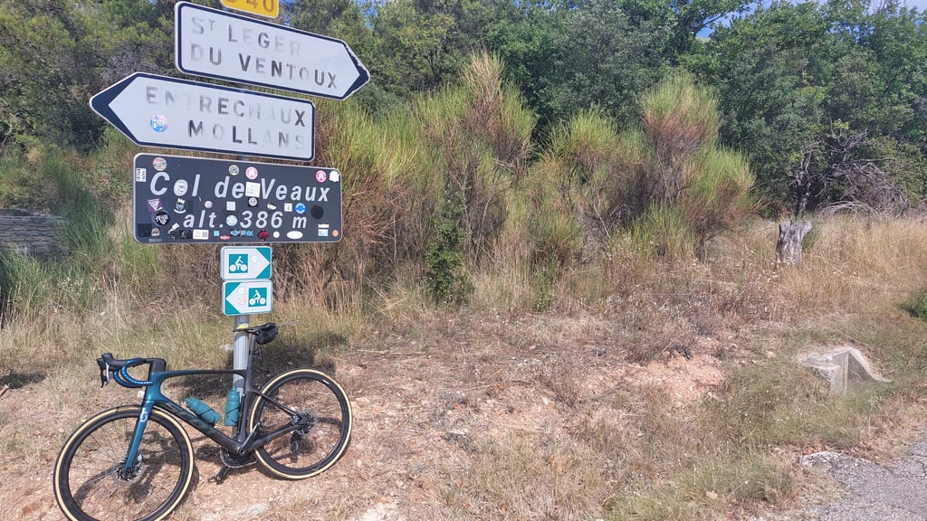
Col de Veaux from Le Toulourenc is a climb in the region Drôme. It is 1.8 mi long and bridges 276 ft of vertical ascent with an average gradient of 2.9%, resulting in a difficulty score of 38. The top of the ascent is located at 1276 ft above sea level. Climbfinder users shared 2 reviews of this climb and uploaded 3 photos.

Road name: Route de Veaux

3.0 by Paul-P
This is an automatic translation, the original language is: Dutch.
From Malaucene descend to the Toulourenc and up again to Pierevon. That last stretch is crowded with cars's because of swimmers in the Toulourenc. But there is no alternative, or you have to return to Malaucene.... read more

Photos (3)

Col de Veaux from Le Toulourenc
transparant thumb
transparant thumb
transparant thumb

Your uploads (max 4)

Welcome! Please activate your account if you would like to share something. Look for the verification email in your inbox.

If you want to upload your photos, you need to create an account. It only takes 1 minute and it's completely free.

  • Receive free climbfinder goodies for your reviews & photos.
  • Create a bucket list and check off conquered climbs.
  • Add missing climbs.
Continue with GoogleContinue with Google Continue with FacebookContinue with Facebook Continue with AppleContinue with Apple Sign up with email
By signing up you agree to our terms of service and confirm that you have read our privacy & content policy.

Reviews (2)

5.0
4.0
3.0
2.0
1.0
Paul-P
9 Mo 3.0 via the Climbfinder app
This is an automatic translation, the original language is: Dutch. Show original

From Malaucene descend to the Toulourenc and up again to Pierevon. That last stretch is crowded with cars's because of swimmers in the Toulourenc. But there is no alternative, or you have to return to Malaucene.

Vanuit Malaucene afdalen tot aan de Toulourenc en weer omhoog tot Pierevon. Dat laatste stukje is druk met auto's vanwege zwemmers in de Toulourenc. Maar een alternatief is er niet, of je moet terug naar Malaucene.

Col de Veaux from Le Toulourenc
Dashboard
LucJansen
2 y 4.0 00:17:39 (6.2 mph)
This is an automatic translation, the original language is: Dutch. Show original

Climbed on 1 July 2021, but partly over this route because I came from Saint-Leger-du-Ventoux. A longer and more beautiful climb. I recommend its inclusion as an alternative. It is a beautiful cycling environment here and I enjoyed this day! Good road surface and little traffic. Lots of cyclists in the photo as we are on holiday with the cycling club (83920 La Motte)!

Beklommen op 1 juli 2021, maar gedeeltelijk over deze route want ik kwam vanuit Saint-Leger-du-Ventoux. Een langere en fraaiere klim. Ik beveel aan dat deze als alternatief wordt opgenomen. Het is hier een mooie fietsomgeving en ik heb van deze dag genoten! Goed wegdek en weinig verkeer. Veel cyclistes op de foto want we zijn met de fietsclub (83920 La Motte) op vakantie!

Col de Veaux from Le Toulourenc
Dashboard

Climbing times

5 mph 00:21:51
7 mph 00:15:28
9 mph 00:12:03
12 mph 00:09:03

Road surface condition

0% 100% 0%
Based on 1 vote
Share your knowledge. What was the road condition during your ascent?

Traffic

0% 100% 0%
Based on 1 vote
Your experience counts. How much traffic did you encounter during the climb?

Frequently Asked Questions

You don't need special gearing for Col de Veaux from Le Toulourenc. The slope isn't long or steep enough to require much shifting down. You can conquer this climb on power alone. However, a compact gearing system with a smallest front chainring of 34 and largest rear sprocket of 28 or 30 is always nice if you enjoy cycling uphill. This helps maintain a smooth cadence.

Col de Veaux from Le Toulourenc falls into the 5th category. With good fitness, you can ride it up with speed and power. If you have less training, shift down and climb smoothly.

Col de Veaux from Le Toulourenc is 1.8 mi long.

The average gradient of Col de Veaux from Le Toulourenc is 2.9%.

Col de Veaux from Le Toulourenc has a steepest segment with an average gradient of 7.7%.

The summit of Col de Veaux from Le Toulourenc is at 1276 ft.

At a slow pace of 5 mph, it takes about 00:21:51 to climb Col de Veaux from Le Toulourenc. At 7 mph the time is 00:15:28, and at 9 mph 00:12:03. For the fastest cyclists, 00:09:03 is an achievable time.

Col de Veaux from Le Toulourenc is located in the region Drôme in France.

This page is better in the app

Climbfinder app
Climbfinder
(Free)
Open