View on map
© MapLibre | OpenStreetMap contributors
1%
2%
4%
6%
8%
10%
12%
15%
20%

Col de la Forclaz from La Croix

4.0
1 review/story | Elevation profile | 1 photo
Tips nearby
Col de la Forclaz from La Croix
transparant thumb
transparant thumb
transparant thumb
transparant thumb
transparant thumb
transparant thumb
transparant thumb
Your achievable time
Calculating based on your best performances...
Relaxed
Maximum
W/kg
W/kg
W/kg
Analyze your climbing performance
Detailed insight into your climbing performance & automatically check off climbs
Based on your best performances.
Your best attempt:
Number of attempts:
Elevation profile Col de la Forclaz from La Croix

Statistics

Difficulty points 865
Length 7.1 mi
Average gradient 8.5%
Steepest segment 15.3%
Total ascent 3179 ft
Feedback about this climb?
Show climbs nearby Export to GPS device

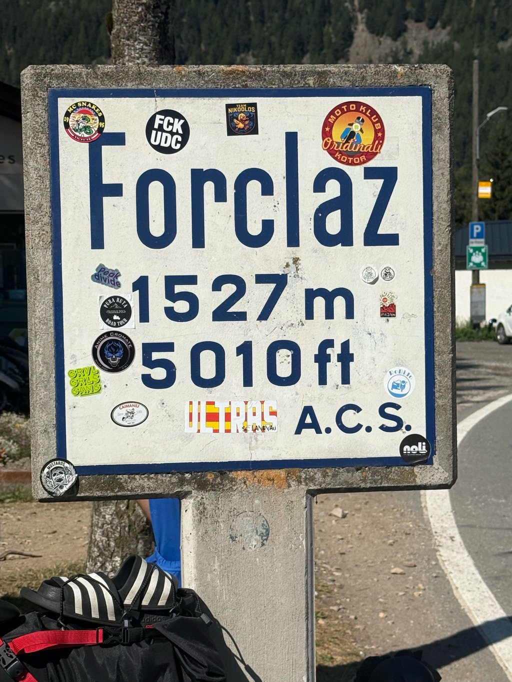
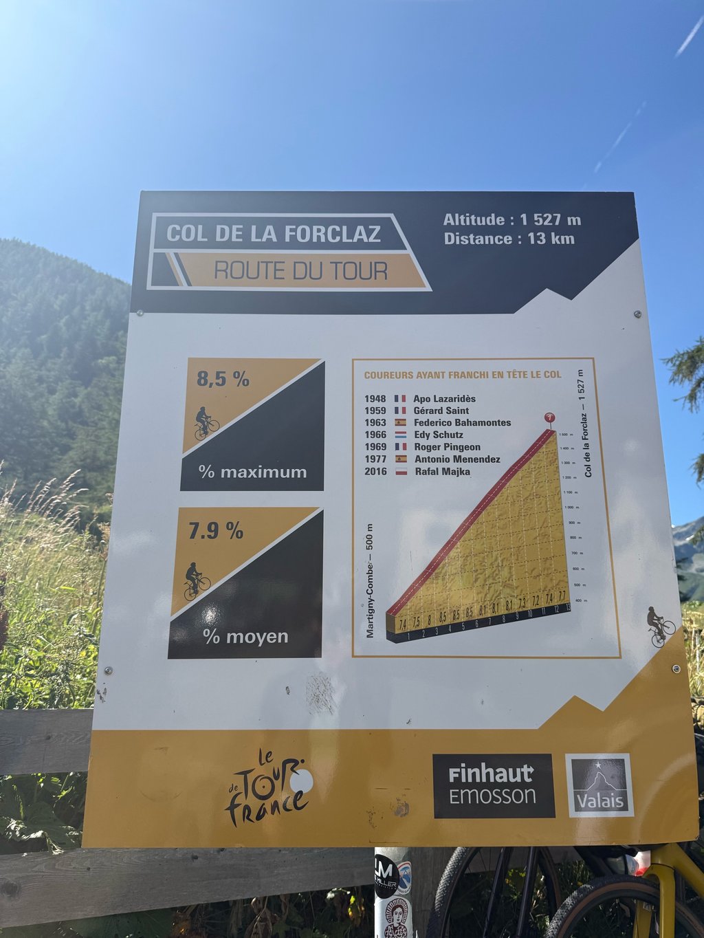
Col de la Forclaz from La Croix is a climb in the region Valais. It is 7.1 mi long and bridges 3179 ft of vertical ascent with an average gradient of 8.5%, resulting in a difficulty score of 865. The top of the ascent is located at 5020 ft above sea level. Climbfinder users shared 1 review/story of this climb and uploaded 1 photo.

Road names: Route de la combe & Route de la Forclaz

4.0 by _superver
This is an automatic translation, the original language is: Dutch.
Ridden early in the dark. It starts out so insanely steep. It is actually a shortcut through a residential area. As a result, you don't encounter much traffic. You get no rest anywhere and it's raking until you reach the top. Every now and then you have a view over the valley where Martigny is located. At the top is some catering and a toilet. You are also close to France here. The climb is one that looks a bit Ardennes-like because you climb through a neighbourhood towards a fores... read more

Photos (1)

Col de la Forclaz from La Croix
transparant thumb
transparant thumb
transparant thumb
transparant thumb
transparant thumb

Your uploads (max 4)

Welcome! Please activate your account if you would like to share something. Look for the verification email in your inbox.

If you want to upload your photos, you need to create an account. It only takes 1 minute and it's completely free.

  • Receive free climbfinder goodies for your reviews & photos.
  • Create a bucket list and check off conquered climbs.
  • Add missing climbs.
Continue with GoogleContinue with Google Continue with FacebookContinue with Facebook Continue with AppleContinue with Apple Sign up with email
By signing up you agree to our terms of service and confirm that you have read our privacy & content policy.

Reviews (1)

5.0
4.0
3.0
2.0
1.0
_superver
1 y 4.0
This is an automatic translation, the original language is: Dutch. Show original

Ridden early in the dark. It starts out so insanely steep. It is actually a shortcut through a residential area. As a result, you don't encounter much traffic. You get no rest anywhere and it's raking until you reach the top.
Every now and then you have a view over the valley where Martigny is located. At the top is some catering and a toilet. You are also close to France here.

The climb is one that looks a bit Ardennes-like because you climb through a neighbourhood towards a forest. The tarmac is much better though, and it takes a very long time!

Vroeg in het donker gereden. Het begint zo waanzinnig steil. Het is eigenlijk een sluiproute door een woonwijk. Daardoor kom je weinig verkeer tegen. Je krijgt nergens rust en het is harken tot je op de top bent.
Zo nu en dan heb je uitzicht over het dal waar Martigny in ligt. Aan de top zit wat horeca en een toilet. Je bent hier tevens in de buurt van Frankrijk.

De klim is er eentje die wat Ardennen-achtig aandoet omdat je door een wijk richting een bos klimt. Het asfalt is wel vele malen beter, en het duurt erg lang!

Col de la Forclaz from La Croix
Dashboard

Climbing times

5 mph 01:25:21
7 mph 01:00:25
9 mph 00:47:05
12 mph 00:35:22

Road surface condition

50% 50% 0%
Based on 4 votes
Share your knowledge. What was the road condition during your ascent?

Traffic

50% 25% 25%
Based on 4 votes
Your experience counts. How much traffic did you encounter during the climb?

Frequently Asked Questions

Col de la Forclaz can be cycled from 3 sides. Col de la Forclaz from Le Châtelard is the most popular side, but the summit can also be reached via Col de la Forclaz from La Croix & Col de la Forclaz from Martigny.

Col de la Forclaz from La Croix is a challenging ascent. For this type of climbing, we recommend mountain gearing, specifically a compact system. This means a small front chainring of 34 teeth, combined with a rear cassette where, depending on your level, strength, and experience, you choose a sprocket with 30, 32, or even 34 teeth. Remember that a smooth cadence is always more efficient!

Col de la Forclaz from La Croix is a first-category climb: long and tough. Do not underestimate this climb. Many famous Tour de France cols fall into this category. Prepare for a long, challenging ride. Only well-trained riders will reach the top smoothly. Make sure you have a road bike with climbing gears and enough training; otherwise, it will be a struggle.

Col de la Forclaz from La Croix is 7.1 mi long.

The average gradient of Col de la Forclaz from La Croix is 8.5%.

Col de la Forclaz from La Croix has a steepest segment with an average gradient of 15.3%.

The summit of Col de la Forclaz from La Croix is at 5020 ft.

At a slow pace of 5 mph, it takes about 01:25:21 to climb Col de la Forclaz from La Croix. At 7 mph the time is 01:00:25, and at 9 mph 00:47:05. For the fastest cyclists, 00:35:22 is an achievable time.

Col de la Forclaz from La Croix is located in the region Valais in Switzerland.

This page is better in the app

Climbfinder app
Climbfinder
(Free)
Open