| Beautiful scenery |
| 3 hairpin turns |
| #33 toughest climb of Auvergne |
| #40 most elevation gain of Auvergne |
| #59 longest climb of Puy-de-Dôme |
| #98 average steepest climb of Puy-de-Dôme |
Col de Ceyssat is a climb in the region Puy-de-Dôme. It is 5.2 mi long and bridges 1762 ft of vertical ascent with an average gradient of 6.5%, resulting in a difficulty score of 394. The top of the ascent is located at 3530 ft above sea level. Climbfinder users shared 2 reviews of this climb and uploaded 3 photos.
Road name: Route de Puy de Dome
3.0 by pierre81This is an automatic translation, the original language is: French.My training pass when I lived in Clermont. The climb can be divided into three parts: the first up to Fontanas is very pleasant and regular (except for the exit from Royat, which is quite steep) in a natural setting, with a few hairpins and small bridges. Between Fontanas and the Puy-de-Dôme car park, there is more traffic and the gradients are more rolling, but exposed to the wind. This is the tricky part. For the final stretch, after the Puy-de-Dôme car park, there is a slope of increasing d... read more
Welcome! Please activate your account if you would like to share something. Look for the verification email in your inbox.
If you want to upload your photos, you need to create an account. It only takes 1 minute and it's completely free.
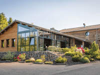
My training pass when I lived in Clermont. The climb can be divided into three parts: the first up to Fontanas is very pleasant and regular (except for the exit from Royat, which is quite steep) in a natural setting, with a few hairpins and small bridges. Between Fontanas and the Puy-de-Dôme car park, there is more traffic and the gradients are more rolling, but exposed to the wind. This is the tricky part. For the final stretch, after the Puy-de-Dôme car park, there is a slope of increasing difficulty, right in the middle of the woods. The surface here is excellent. There's an inn at the summit where you can recharge your batteries. I recommend that you then descend to the village of Ceyssat, which gives its name to the pass, and then follow the road to Vulcania for a nice loop around the volcanoes.
Mon col d'entraînement lorsque je vivais à Clermont. On peut découper l'ascension en trois parties : une première jusqu'à Fontanas, très agréable et régulière (sauf la sortie de Royat, assez raide) dans un écrin de nature, avec quelques épingles et des petits ponts. Entre Fontanas et le parking du Puy-de-Dôme, on retrouve plus de circulation et des pourcentages plus roulants, mais exposés au vent. C'est la partie un peu pénible. Pour le final, après le parking du Puy-de-Dôme, on retrouve une pente dont la difficulté est croissante, en plein milieu des bois. Le revêtement est excellent par ici. Une auberge vous attend au sommet pour reprendre des forces. Je vous recommande ensuite de redescendre vers le village de Ceyssat, qui donne son nom au col, puis de suivre la route vers Vulcania pour faire une belle boucle autour des volcans.
Before you start the 'real' climb on leaving Royat, if you started in Clermont-Ferrand, you have already had quite a bit of climbing to do. Up to Fontanas definitely a beautiful and occasionally tough climb through a mostly green world. I find the part from Fontanas to the big roundabout the least enjoyable part of the col. After the roundabout, the second half of the col awaits with impressive views of the Puy de Dome. Until the summit, you cycle on a nice road through the forest until the top. Except for the last kilometre, the second half of the col runs much better than the stretch up to Fontanas. Fun to do, but if you are unlucky you will have to deal with a lot of traffic.
Voordat je bij het verlaten van Royat aan de 'echte' beklimming begint heb je, als je in Clermont-Ferrand bent gestart, al aardig wat klimwerk voor de kiezen gehad. Tot Fontanas zonder meer een prachtige en af en toe pittige beklimming door een veelal groene wereld. Het stuk van Fontanas tot aan de grote rotonde vind ik het minst leuke stuk van de col. Na de rotonde wacht de tweede helft van de col met een indrukwekkend zicht op de Puy de Dome. Tot de top fiets je over een mooie weg door het bos tot de top. Op de laatste kilometer na loopt de tweede helft van de col stukken beter dan het stuk tot Fontanas. Leuk om te doen, maar als je pech hebt krijg je te maken met veel verkeer.
| 5 mph | 01:02:12 |
| 7 mph | 00:44:02 |
| 9 mph | 00:34:19 |
| 12 mph | 00:25:47 |
This page is better in the app