View on map
© MapLibre | OpenStreetMap contributors
1%
2%
4%
6%
8%
10%
12%
15%
20%

Bombaye via Chemin de l’Andelaine

3.0
4 reviews | Elevation profile | 7 photos
Tips nearby
Bombaye via Chemin de l’Andelaine
transparant thumb
Your achievable time
Calculating based on your best performances...
Relaxed
Maximum
W/kg
W/kg
W/kg
Analyze your climbing performance
Detailed insight into your climbing performance & automatically check off climbs
Based on your best performances.
Your best attempt:
Number of attempts:
Elevation profile Bombaye via Chemin de l’Andelaine

Statistics

Difficulty points 13
Length 0.8 mi
Average gradient 2.7%
Steepest segment 6%
Total ascent 112 ft
Feedback about this climb?
Show climbs nearby Export to GPS device

Bombaye via Chemin de l’Andelaine is a climb in the region Pays de Herve. It is 0.8 mi long and bridges 112 ft of vertical ascent with an average gradient of 2.7%, resulting in a difficulty score of 13. The top of the ascent is located at 453 ft above sea level. Climbfinder users shared 4 reviews of this climb and uploaded 7 photos.

Road names: Chemin de L'Andelaine & Rue du Tilleul

This is an automatic translation, the original language is: Dutch.
5/10 Fine 'climb', nothing crazy but not boring either. Beautiful surroundings and not too busy... read more

Photos (7)

Bombaye via Chemin de l’Andelaine
transparant thumb
transparant thumb
transparant thumb
transparant thumb
transparant thumb

Your uploads (max 4)

Welcome! Please activate your account if you would like to share something. Look for the verification email in your inbox.

If you want to upload your photos, you need to create an account. It only takes 1 minute and it's completely free.

  • Receive free climbfinder goodies for your reviews & photos.
  • Create a bucket list and check off conquered climbs.
  • Add missing climbs.
Continue with GoogleContinue with Google Continue with FacebookContinue with Facebook Continue with AppleContinue with Apple Sign up with email
By signing up you agree to our terms of service and confirm that you have read our privacy & content policy.

Reviews (4)

5.0
4.0
3.0
2.0
1.0
JurneSleddens
7 Mo 3.0
This is an automatic translation, the original language is: Dutch. Show original

5/10 Fine 'climb', nothing crazy but not boring either. Beautiful surroundings and not too busy

5/10 Prima 'beklimming', niks geks maar ook niet vervelend. Mooie omgeving en niet te druk

Dashboard
Maikel1989
1 y 3.0
This is an automatic translation, the original language is: Dutch. Show original

Slight undulating climb. Only in the last stretch does it get real climbing for a while. The beginning is not so attractive but the second part is not so bad.

Lichte golvende klim. Pas in het laatste stuk wordt het even echt klimmen. Het begin is niet zo aantrekkelijk maar het tweede deel valt mee.

Dashboard
BikerJohan
1 y 3.0
This is an automatic translation, the original language is: Dutch. Show original

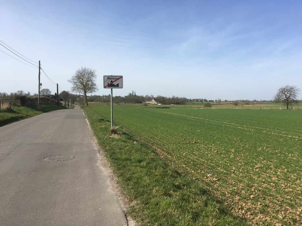
The climb starts at the last houses of Warsage. First it rises slightly and then you descend a bit. This is followed by the steepest part of the climb up to the first houses of Berneau. In the village it then flattens out until the summit on Rue del'Egelise.

De klim begint bij de laatste huizen van Warsage. Eerst loopt het wat licht op en daal je vervolgens een stuk. Hierna volgt tot aan de eerste huizen van Berneau het steilste stuk van de klim. In het dorp vlakt het daarna af tot aan de top op Rue del'Egelise.

Dashboard
Fedor
4 y 3.0
This is an automatic translation, the original language is: Dutch. Show original

Light climb through a nice landscape. Between the houses of Warsage starts a slight climb. If you leave the built-up area, there is a slight decline after which it really starts to climb. In the descending part you have a nice view on a bunker high up on the slope on the left side and on (among others) the church of Bombaye diagonally to the right. In Bombaye it becomes flatter again, here it is riding to the end. Just before Bombaye far view to the right and back. Reasonable to good asphalt.

Lichte klim door een aardig landschap. Tussen de huizen van Warsage begint het lichtjes te klimmen. Als je de bebouwde kom verlaat even een lichte daling waarna het pas echt een beetje gaat klimmen. In het dalende gedeelte mooi zicht op een bunker hoog op de helling aan de linkerkant en op (o.a. de kerk van) Bombaye schuin rechts vooruit. In Bombaye wordt het weer vlakker, hier is het uitrijden tot het eind. Vlak voor Bombaye ver uitzicht naar rechts en naar achteren. Redelijk tot goed asfalt.

Bombaye via Chemin de l’Andelaine
Dashboard

Climbing times

5 mph 00:09:33
7 mph 00:06:46
9 mph 00:05:16
12 mph 00:03:57

Road surface condition

0% 0% 100%
Based on 1 vote
Share your knowledge. What was the road condition during your ascent?

Traffic

0% 100% 0%
Based on 1 vote
Your experience counts. How much traffic did you encounter during the climb?

Frequently Asked Questions

You don't need special gearing for Bombaye via Chemin de l’Andelaine. The slope isn't long or steep enough to require much shifting down. You can conquer this climb on power alone. However, a compact gearing system with a smallest front chainring of 34 and largest rear sprocket of 28 or 30 is always nice if you enjoy cycling uphill. This helps maintain a smooth cadence.

Bombaye via Chemin de l’Andelaine is not tough enough to be assigned a mountain category. This means that even untrained cyclists can reach the top without any problems on this climb.

Bombaye via Chemin de l’Andelaine is 0.8 mi long.

The average gradient of Bombaye via Chemin de l’Andelaine is 2.7%.

Bombaye via Chemin de l’Andelaine has a steepest segment with an average gradient of 6%.

The summit of Bombaye via Chemin de l’Andelaine is at 453 ft.

At a slow pace of 5 mph, it takes about 00:09:33 to climb Bombaye via Chemin de l’Andelaine. At 7 mph the time is 00:06:46, and at 9 mph 00:05:16. For the fastest cyclists, 00:03:57 is an achievable time.

Bombaye via Chemin de l’Andelaine is located in the region Liège Province in Belgium.

This page is better in the app

Climbfinder app
Climbfinder
(Free)
Open