View on map
© MapLibre | OpenStreetMap contributors
1%
2%
4%
6%
8%
10%
12%
15%
20%

Champ de Préval from Archennes

3.5
2 reviews | Elevation profile | 4 photos
Tips nearby
Champ de Préval from Archennes
transparant thumb
transparant thumb
transparant thumb
transparant thumb
Your achievable time
Calculating based on your best performances...
Relaxed
Maximum
W/kg
W/kg
W/kg
Analyze your climbing performance
Detailed insight into your climbing performance & automatically check off climbs
Based on your best performances.
Your best attempt:
Number of attempts:
Elevation profile Champ de Préval from Archennes

Statistics

Difficulty points 35
Length 0.8 mi
Average gradient 3.7%
Steepest segment 11.3%
Total ascent 164 ft

Short recap

Beautiful scenery
Feedback about this climb?
Show climbs nearby Export to GPS device

Champ de Préval from Archennes is a climb in the region Ardennes Brabançonnes. It is 0.8 mi long and bridges 164 ft of vertical ascent with an average gradient of 3.7%, resulting in a difficulty score of 35. The top of the ascent is located at 305 ft above sea level. Climbfinder users shared 2 reviews of this climb and uploaded 4 photos.

Road names: Préval & Rue des Corbeaux
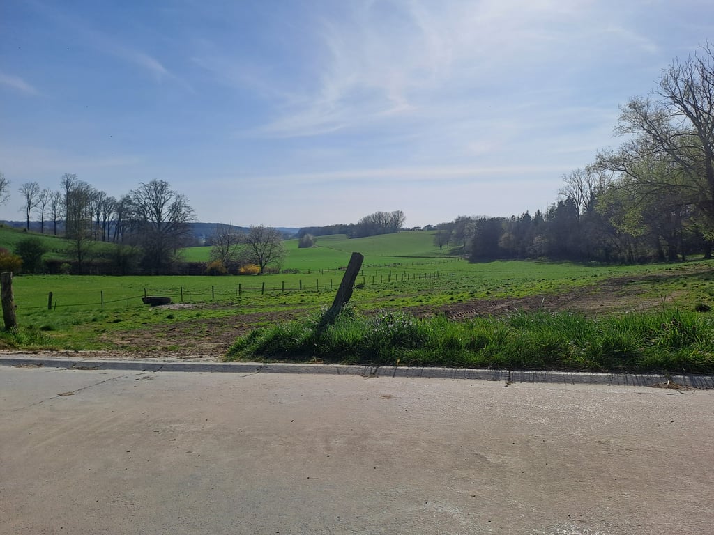
4.0 by JulienD55
This is an automatic translation, the original language is: French.
the first few metres are surrounded by trees, then you come out onto a magnificent road between the fields and in the distance you see the wall rising up in front of you. It goes up and up until you reach some really steep slopes, but for the setting I would still advise you to go down there.... read more

Photos (4)

Champ de Préval from Archennes
transparant thumb
transparant thumb

Your uploads (max 4)

Welcome! Please activate your account if you would like to share something. Look for the verification email in your inbox.

If you want to upload your photos, you need to create an account. It only takes 1 minute and it's completely free.

  • Receive free climbfinder goodies for your reviews & photos.
  • Create a bucket list and check off conquered climbs.
  • Add missing climbs.
Continue with GoogleContinue with Google Continue with FacebookContinue with Facebook Continue with AppleContinue with Apple Sign up with email
By signing up you agree to our terms of service and confirm that you have read our privacy & content policy.

Reviews (2)

5.0
4.0
3.0
2.0
1.0
JulienD55
11 Mo 4.0
This is an automatic translation, the original language is: French. Show original

the first few metres are surrounded by trees, then you come out onto a magnificent road between the fields and in the distance you see the wall rising up in front of you. It goes up and up until you reach some really steep slopes, but for the setting I would still advise you to go down there.

les premiers mètre sont entourée d'arbre ensuite vous sortez dans une route magnifique entre les champs et au loins on voit le mur se dresser devant nous cela monte de plus en plus jusqu'à atteindre des pentes vraiment raide mais pour le cadre je vous conseil quand meme de passer par la bas

Dashboard
StevenVGH
3 y 3.0
This is an automatic translation, the original language is: Dutch. Show original

From Archennes (Eerken for the Dutch speakers), turn left into the insignificant road that leads to the foot of the Champ de Préval.
The first few hectares are sheltered by a hollow road. Afterwards, you find yourself between the vast fields, with a beautiful panoramic view for free on top of it.
In the distance, you can see the steeper part of this slope looming ahead of you.
The difficulty depends on several factors: form of the day, ridden kilometres and altimeters, etc. but in general, this slope should not be difficult for the average cyclist.

Vanuit Archennes (Eerken voor de Nederlandstaligen) sla je linksaf het onbeduidende straatje in dat je naar de voet van de Champ de Préval brengt.
De eerste hectometers rijdt je beschut in een holle weg. Nadien kom je tussen de weidse velden terecht, met een mooi panoramisch uitzicht er gratis bovenop.
In de verte zie je het steilere stuk van deze helling voor je opdoemen.
De zwaarte hiervan is afhankelijk van verschillende factoren: vorm van de dag, gereden kilometers en hoogtemeters, etc. maar over het algemeen zou deze helling zeker geen moeilijkheden mogen bieden aan de gemiddelde wielertoerist.

Dashboard

Climbing times

5 mph 00:10:07
7 mph 00:07:10
9 mph 00:05:35
12 mph 00:04:11

Road surface condition

100% 0% 0%
Based on 2 votes
Share your knowledge. What was the road condition during your ascent?

Traffic

100% 0% 0%
Based on 2 votes
Your experience counts. How much traffic did you encounter during the climb?

Frequently Asked Questions

You don't need special gearing for Champ de Préval from Archennes. The slope isn't long or steep enough to require much shifting down. You can conquer this climb on power alone. However, a compact gearing system with a smallest front chainring of 34 and largest rear sprocket of 28 or 30 is always nice if you enjoy cycling uphill. This helps maintain a smooth cadence.

Champ de Préval from Archennes falls into the 5th category. With good fitness, you can ride it up with speed and power. If you have less training, shift down and climb smoothly.

Champ de Préval from Archennes is 0.8 mi long.

The average gradient of Champ de Préval from Archennes is 3.7%.

Champ de Préval from Archennes has a steepest segment with an average gradient of 11.3%.

The summit of Champ de Préval from Archennes is at 305 ft.

At a slow pace of 5 mph, it takes about 00:10:07 to climb Champ de Préval from Archennes. At 7 mph the time is 00:07:10, and at 9 mph 00:05:35. For the fastest cyclists, 00:04:11 is an achievable time.

Champ de Préval from Archennes is located in the region Walloon Brabant in Belgium.

This page is better in the app

Climbfinder app
Climbfinder
(Free)
Open