View on map
© MapLibre | OpenStreetMap contributors
1%
2%
4%
6%
8%
10%
12%
15%
20%

Bohon

3.5
2 reviews | Elevation profile | 2 photos
In some places the road surface of this climb is bad, but it can be ridden with a road bike.
Tips nearby
Bohon
Bohon
transparant thumb
transparant thumb
transparant thumb
transparant thumb
transparant thumb
transparant thumb
Your achievable time
Calculating based on your best performances...
Relaxed
Maximum
W/kg
W/kg
W/kg
Analyze your climbing performance
Detailed insight into your climbing performance & automatically check off climbs
Based on your best performances.
Your best attempt:
Number of attempts:
Elevation profile Bohon
bad road
paved

Statistics

Difficulty points 46
Length 0.3 mi
Average gradient 8.5%
Steepest segment 12.4%
Total ascent 154 ft

Short recap

Hidden gem
Bad road
#38 average steepest climb of Belgian Luxembourg
Feedback about this climb?
Show climbs nearby Export to GPS device

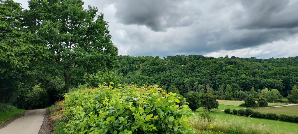
Bohon is a climb in the region Condroz - Famenne. It is 0.3 mi long and bridges 154 ft of vertical ascent with an average gradient of 8.5%, resulting in a difficulty score of 46. The top of the ascent is located at 614 ft above sea level. Climbfinder users shared 2 reviews of this climb and uploaded 2 photos.

Road name: Bohon

3.0 by JarnoC44
This is an automatic translation, the original language is: Dutch.
Nice climb with solid stretch around the first bend. Terasje at the top is a nice consolation prize.... read more

Photos (2)

Bohon
Bohon
transparant thumb
transparant thumb
transparant thumb
transparant thumb

Your uploads (max 4)

Welcome! Please activate your account if you would like to share something. Look for the verification email in your inbox.

If you want to upload your photos, you need to create an account. It only takes 1 minute and it's completely free.

  • Receive free climbfinder goodies for your reviews & photos.
  • Create a bucket list and check off conquered climbs.
  • Add missing climbs.
Continue with GoogleContinue with Google Continue with FacebookContinue with Facebook Continue with AppleContinue with Apple Sign up with email
By signing up you agree to our terms of service and confirm that you have read our privacy & content policy.

Reviews (2)

5.0
4.0
3.0
2.0
1.0
JarnoC44
10 Mo 3.0 via the Climbfinder app
This is an automatic translation, the original language is: Dutch. Show original

Nice climb with solid stretch around the first bend. Terasje at the top is a nice consolation prize.

Mooie beklimming met stevig stuk omtrent de eerste bocht. Terasje aan de top is een mooie troostprijs.

Bohon
Dashboard
dwelleke
4 y 4.0
This is an automatic translation, the original language is: Dutch. Show original

Without the bad road surface this would be a winner: beautiful scenery, very quiet and (for the enthusiasts) steep but not too steep! If you come from the Ourthe (Barvaux or Durbuy) you turn here and you immediately see that you'll have to overcome some altitude meters in a short distance. After a short run-up, the steepest parts start immediately and only when you've made the right turn, you'll feel the steepness decrease. I've done this one a few times the last few weeks because I was at camp with the youth movement on the terrain adjacent to this climb, wonderful! Make sure you stop at café 1850 for a refreshing drink.

Zonder het slechte wegdek zou dit een topper zijn: prachtige omgeving, zeer rustig en (voor de liefhebbers) steil maar niet te steil! Als je van de Ourthe komt (Barvaux of Durbuy) draai je hier op en zie je meteen dat je wat hoogtemeters op korte afstand zal moeten overbruggen. Na een korte aanloop beginnen meteen de steilste stukken en pas wanneer je de bocht naar rechts achter de rug hebt, voel je de steiltegraad afzwakken. Ik heb deze enkele malen gedaan afgelopen weken omdat ik met de jeugdbeweging op kamp was op het terrein grenzend aan deze klim, heerlijk! Stop boven trouwens zeker en vast bij café 1850 voor een verfrissend drankje.

Dashboard

Climbing times

5 mph 00:04:08
7 mph 00:02:56
9 mph 00:02:17
12 mph 00:01:43

Road surface condition

0% 0% 100%
Based on 1 vote
Share your knowledge. What was the road condition during your ascent?

Traffic

100% 0% 0%
Based on 1 vote
Your experience counts. How much traffic did you encounter during the climb?

Frequently Asked Questions

You don't need special gearing for Bohon. The slope isn't long or steep enough to require much shifting down. You can conquer this climb on power alone. However, a compact gearing system with a smallest front chainring of 34 and largest rear sprocket of 28 or 30 is always nice if you enjoy cycling uphill. This helps maintain a smooth cadence.

Bohon falls into the 5th category. With good fitness, you can ride it up with speed and power. If you have less training, shift down and climb smoothly.

Bohon is 0.3 mi long.

The average gradient of Bohon is 8.5%.

Bohon has a steepest segment with an average gradient of 12.4%.

The summit of Bohon is at 614 ft.

At a slow pace of 5 mph, it takes about 00:04:08 to climb Bohon. At 7 mph the time is 00:02:56, and at 9 mph 00:02:17. For the fastest cyclists, 00:01:43 is an achievable time.

Bohon is located in the region Condroz - Famenne in Belgium.

This page is better in the app

Climbfinder app
Climbfinder
(Free)
Open