Tips nearby


| 4 hairpin turns |
| #60 toughest climb of Burgundy-Franche-Comté |
| #84 most elevation gain of Grand Est |
| #78 longest climb of Grand Est |
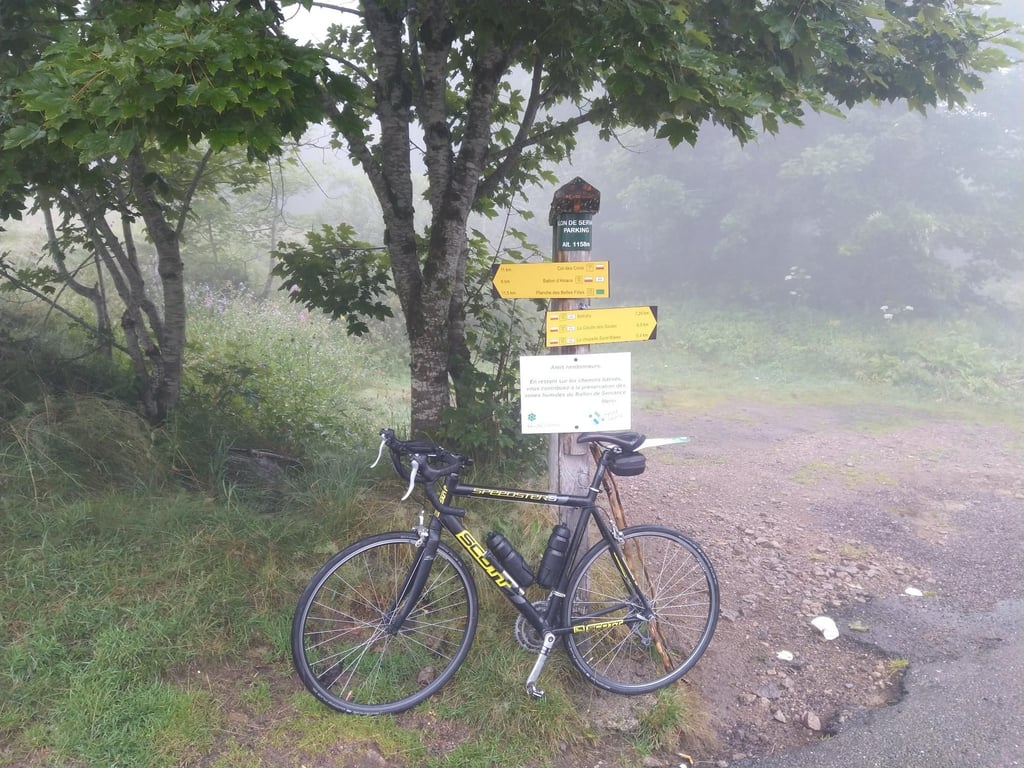
Ballon de Servance from Col des Croix is a climb in the region Vosges. It is 6.3 mi long and bridges 1568 ft of vertical ascent with an average gradient of 4.7%, resulting in a difficulty score of 282. The top of the ascent is located at 3789 ft above sea level. Climbfinder users shared 8 reviews of this climb and uploaded 11 photos.
Road name: Route des Forts
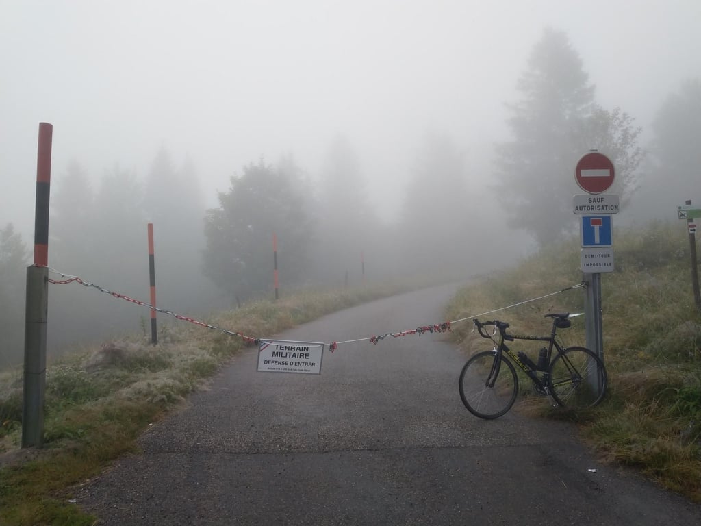
2.0 by Joeri_LaureysThis is an automatic translation, the original language is: Dutch.Gee, what can you say about this side of the Servance. You don't drive up this one? It's a boring straight line to the top of the Croix. It is the shortest way to the Planche des Belles Filles, if you come from the region Le Thillot / La Bresse. It is not a tough climb. You take it on this side if you e.g. 'my favorite' the Col des Chevrères to avoid. (Or if your wife wants to, therefore it is on my 'done' list. But otherwise you ride it down and not up. Too boring... read more

Welcome! Please activate your account if you would like to share something. Look for the verification email in your inbox.
If you want to upload your photos, you need to create an account. It only takes 1 minute and it's completely free.
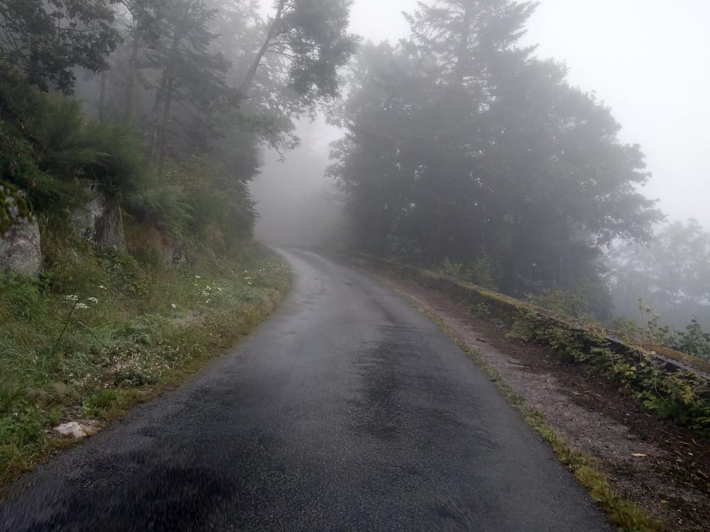
A nice climb through a beautiful forest. The descent was indeed very bumpy—you can't pick up much speed there. We used this climb to ride toward Planche. The other side is much harder, though.
Mooie klim door een mooi bos. Afdaling was inderdaad heel hobbelig je kan er niet veel snelheid maken. We gebruikten deze klim om richting planche te rijden. De andere kant is wel veel lastiger.
This is a good climb for starting with a few days' riding in the Vosges. Bit up and down at first, never really super steep sections. Quiet climb but not much to see
Dit is een goede klim voor te starten met een paar dagen in de Vogezen te rijden. In het begin beetje op en af, nooit echt supersteile stukken. Rustige klim maar niet veel te zien
On its own, this is a gentle climb through the forest but it is a long, boring route with no views anywhere. The percentages are varied which I don't mind. The road surface is not good either, no loose pebbles but a slightly undulating road surface that disrupts your cadence. The summit doesn't amount to much either. Normally I would give this 3 stars but my mood dropped even more because of the descent after it which turned out to be the same road surface. Finally, I took this climb because it is one of the "ballons" and is the shortest route to LPDBF.
Opzich is dit een rustige klim door het bos maar het is een lange, saaie route met nergens een uitzichtje. De percentages zijn gevarieerd wat ik niet erg vind. Het wegdek ligt ook niet goed, geen losse steentjes maar een licht golvend wegdek dat je cadans verstoord. De top stelt ook niet veel voor. Normaal zou ik dit 3 sterren geven maar mijn mood zakte nog meer door de afdaling er na dat hetzelfde wegdek bleek te zijn. Ten slotte nam ik deze klim omdat het een van de "ballons" is en de kortste route naar LPDBF is.
Quite a nice pass, unfortunately not many viewpoints, uphill under woodland, percentage of slope relatively easy apart from at the end with slopes at 9-10%.
Col assez sympa, malheureusement pas beaucoup de point de vue, montée sous bois, pourcentage de la pente relativement facile à part sur la fin avec des pentes à 9-10%.
Nice, gentle climb through the forest. Indeed no views, but beautiful green in spring.
Road surface is good on both sides and according to other experiences this has been different before. Little motorised traffic and that's a good thing because it's actually only slightly wider than a cycle path, despite the stripes in the middle 😉
Mooie, rustige klim door het bos. Inderdaad geen uitzicht, maar in het voorjaar mooi groen.
Wegdek is aan beide kanten goed en volgens de andere ervaringen is dat wel eens anders geweest. Weinig gemotoriseerd verkeer en dat is maar goed ook want het is eigenlijk maar net iets breder dan een fietspad, ondanks de strepen in het midden 😉
Not really recommended, bad road but a handy way to get to the Planche. Descent was in bad shape at the time (2022), as was this road. The descent has since been patched up I see. First part runs easily but the devil is 'm in the tail.
Niet echt een aanrader, slechte weg maar wel een handige weg om bij de Planche te komen. Afdaling lag er destijds (2022) slecht bij, net als deze weg. De afdaling is intussen opgelapt zie ik. Eerste deel loopt makkelijk maar het venijn zit 'm in de staart.
I quite agree with Gorgorbey: 10km for very little. What's more, once you get to the top, there's nothing to see unless you walk another 2km. That said, this little black road is really very pretty. It winds through the forest. The other side looks much more exciting.
Assez d’accord avec Gorgorbey : 10km pour peu de choses. De plus, arrivé en haut, il n’y a rien à voir à moins de marcher encore près de 2km. Cela dit, cette petite route noire est vraiment très mignonne. Elle serpente dans la forêt. L’autre versant semble bien plus excitant.
Gee, what can you say about this side of the Servance. You don't drive up this one? It's a boring straight line to the top of the Croix. It is the shortest way to the Planche des Belles Filles, if you come from the region Le Thillot / La Bresse. It is not a tough climb. You take it on this side if you e.g. 'my favorite' the Col des Chevrères to avoid. (Or if your wife wants to, therefore it is on my 'done' list. But otherwise you ride it down and not up. Too boring...
Goh, wat kan je zeggen over deze kant van de Servance. Deze rij je niet op? Het is een saaie rechte lijn naar de top van de Croix. Het is de kortste weg naar de Planche des Belles Filles, als je vanuit regio Le Thillot / La Bresse komt. Het is geen zware klim. Je neemt hem langs deze kant als je b.v. 'mijn favoriet' de Col des Chevrères wil vermijden. (Of als je vrouw dat wil, daarom is ie op mijn 'done' lijstje. Maar anders rij je dit naar beneden en niet naar boven. Wegens te saai...
| 5 mph | 01:16:00 |
| 7 mph | 00:53:48 |
| 9 mph | 00:41:56 |
| 12 mph | 00:31:30 |
This page is better in the app