| Rank | Climb |
|---|---|
|
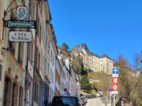
Rue du Moulin from Bofferdange
1.5 km
10.6%
212
|
|
|
Beringerberg from Beringen via Rue Wenzel
2.6 km
7.8%
210
|
|
|
Gousselerbierg from Gosseldange
1.2 km
11.3%
190
|
|
| 4 |
Beringerberg
2.9 km
6.9%
174
|
| 5 |
Keispelt from Durenthal
1.2 km
10.8%
163
|
| 6 |
Sonnebierg from Helmsange
3.5 km
5.4%
160
|
| 7 |
Montée Haute from Steinsel
1.4 km
9.1%
149
|
| 8 |
Rolléngerbierg
3.5 km
5.7%
146
|
| 9 |
Rue de la Forêt via Rue des Sources
2.6 km
6.3%
143
|
| 10 |
Lannenerbierg Southwest from Nagem via Lannen
3.2 km
5.2%
141
|
In the region Gutland cyclists can find 168 interesting climbs between 218 m and 547 m above sea level. Rue du Moulin from Bofferdange is the toughest ascent with a difficulty score of 212. Climbs have an average length of 1.7 km and 87 m of total ascent.
This page is better in the app