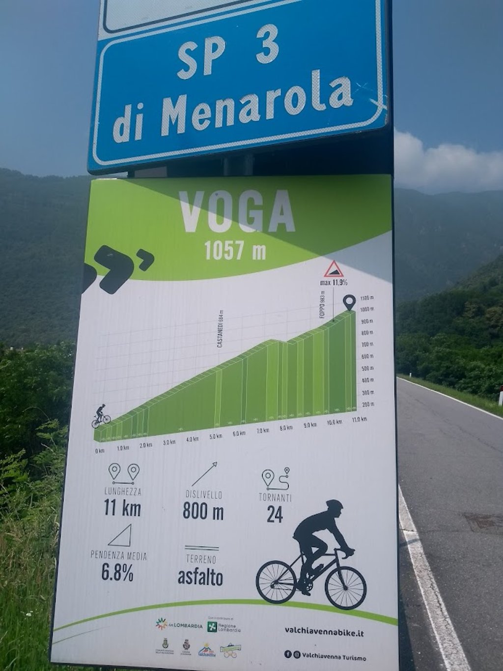
Voga from Gordona is a climb in the region Sondrio. It is 9.7 km long and bridges 773 m of vertical ascent with an average gradient of 8%, resulting in a difficulty score of 775. The top of the ascent is located at 1062 m above sea level. Climbfinder users shared 2 reviews of this climb and uploaded 8 photos.
Road names: Via Coloredo & Strada provinciale 3 di Menarola
4.0 by AlpenTThis is an automatic translation, the original language is: German.Beautiful, pleasant climb that is very varied. Highly recommended, especially because of the great views!... read more

Welcome! Please activate your account if you would like to share something. Look for the verification email in your inbox.
If you want to upload your photos, you need to create an account. It only takes 1 minute and it's completely free.
Beautiful, pleasant climb that is very varied. Highly recommended, especially because of the great views!
Schöner, angenehmer Anstieg, der sehr abwechslungsreiche ist. Sehr zu empfehlen, vor allem wegen den tollen Blicken!
At the right hand exit (Menarola signpost) just before the river bridge when entering Gordona, the climb starts immediately with a straight road firmly uphill. After passing the first village of Coloreda, the narrow route climbs with irregular percentages up the mountainside via many hairpin bends with panoramic views of the wide Chiavenna valley and the Mera river. You cycle through several small villages consisting of a few houses and a church.
After CF end point Voga you could still continue a bit but the asphalt changed into recently laid rough concrete to bring the owners with their cars to the last houses. For a racing bike it stopped somewhat disappointingly at a large electricity pylon at 1320m altitude after 12.6 km.
There is no provisioning on the way, but there are some water sources. Asphalt is not the best. There is hardly any traffic.
Typical climbing route where the narrow road climbs up the wooded valley slope via small villages.
Bij de rechtse afslag (wegwijzer Menarola) vlak voor de rivierbrug bij binnenfietsen van Gordona start de klim direct met rechte weg stevig bergop. Na doorfietsen van eerste dorpje Coloredo klimt de smalle route met onregelmatige percentages de bergflank op via veel haarspeldbochten met panoramische uitzichten op de brede Chiavenna vallei met de Mera rivier. Je fietst door verschillende kleine dorpjes bestaande uit enkele huisjes en een kerkje.
Na CF eindpunt Voga kon je nog een stuk verder al ging het asfalt over in recent aangelegd ruw beton, om de eigenaars met hun wagen bij de laatste huisjes te brengen. Het stopte voor een racefiets enig zins teleurstellend thv grote elektriciteitsmast op 1320m hoogte na 12.6 km.
Er is geen bevoorrading mogelijk onderweg,wel enkele water bronnetjes. Asfalt is niet top. Er is amper verkeer.
Typische klimroute waar de smalle doodlopende weg via kleine dorpjes de beboste valleiflank opklimt.
Heel fijn om te fietsen!
| 7 km/h | 01:23:09 |
| 11 km/h | 00:52:55 |
| 15 km/h | 00:38:48 |
| 19 km/h | 00:30:38 |
This page is better in the app