| Hidden gem |
| 2 hairpin turns |
| #56 longest climb of Aragon |
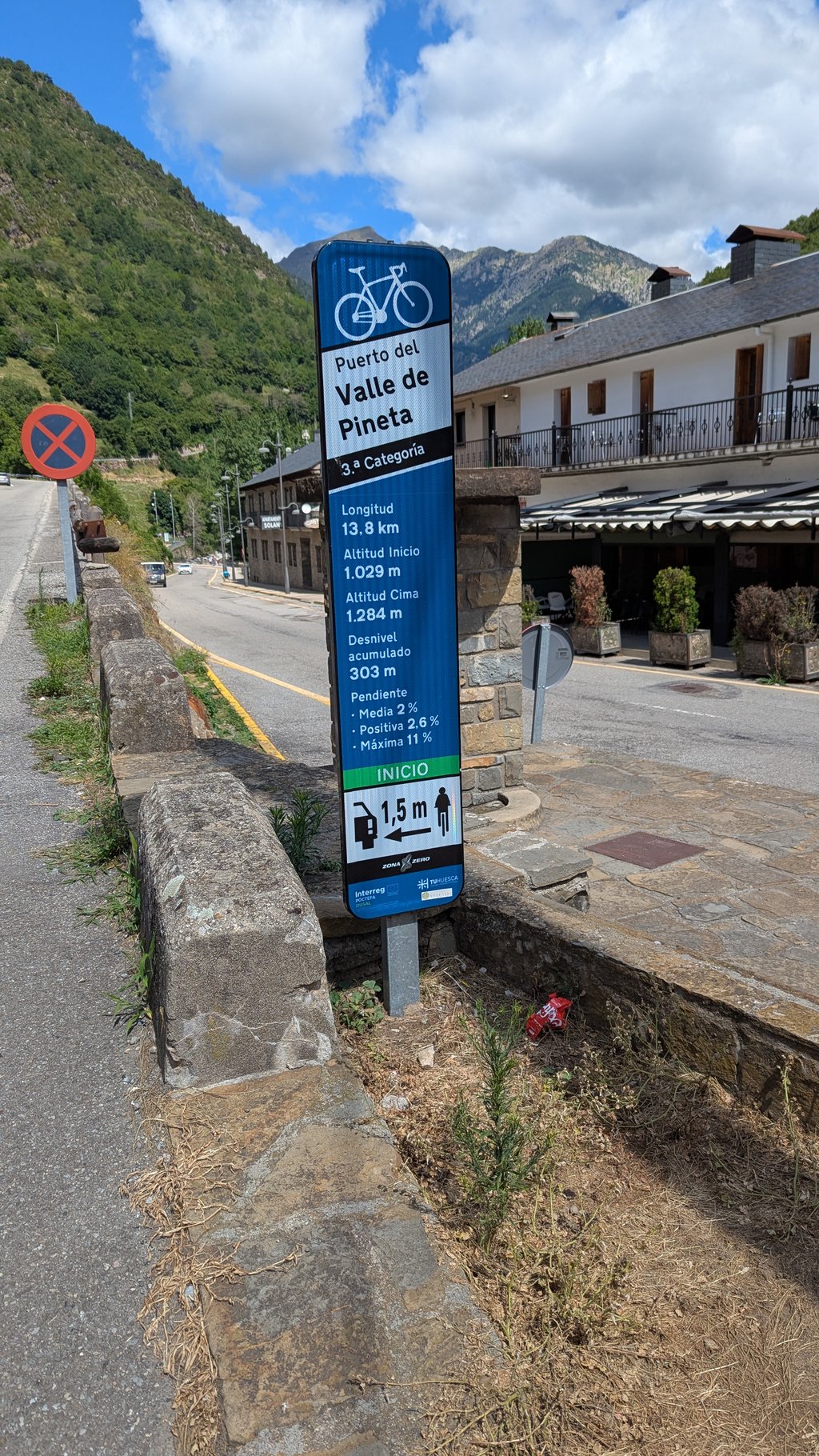
Valle de Pineta from Bielsa is a climb in the region Spanish Pyrenees. It is 14.2 km long and bridges 309 m of vertical ascent with an average gradient of 2.2%, resulting in a difficulty score of 162. The top of the ascent is located at 1292 m above sea level. Climbfinder users shared 3 reviews of this climb and uploaded 2 photos.
Road name: HU-V-6402
3.0 by SiardThis is an automatic translation, the original language is: Dutch.Nice climb to get into where especially the first 1 to 2km are a bit harder. From the dam it is mostly flat and you cycle on a quiet road through the forest and past small hamlets. Halfway there is a campsite where you can fill up with water if needed. Also at3km before the end and at the end is a Rifugio. The road is fine, holes are filled but this makes it a bit bumpy at times. Few pebbles on the road, though the occasional squirrel 😉. A tip is the turn-off towards Espierba about 5km from t... read more
Welcome! Please activate your account if you would like to share something. Look for the verification email in your inbox.
If you want to upload your photos, you need to create an account. It only takes 1 minute and it's completely free.
Nice climb to get into where especially the first 1 to 2km are a bit harder. From the dam it is mostly flat and you cycle on a quiet road through the forest and past small hamlets. Halfway there is a campsite where you can fill up with water if needed. Also at3km before the end and at the end is a Rifugio. The road is fine, holes are filled but this makes it a bit bumpy at times. Few pebbles on the road, though the occasional squirrel 😉. A tip is the turn-off towards Espierba about 5km from the start. This is a climb of only 2.8km on a good road may average 9%. Nice to do in between or during the ride down for some extra challenge!
Leuke klim om in te komen waar vooral de eerste 1 a 2km wat zwaarder zijn. Vanaf de dam is het grotendeels vlak en fiets je over een rustige weg heerlijk door het bos en langs kleine gehuchten. Halverwege is een camping waar je eventueel water kunt bijvullen. Ook is op3km voor het einde en aan het einde een Rifugio. De weg is prima, gaten zijn gevuld maar hierdoor is het soms wat hobbelig. Weinig steentjes op de weg, wel af en toe een eekhoorn 😉. Een tip is de afslag richting Espierba op circa 5km van het begin. Dit is een klim van maar 2,8km over een goede weg mag gemiddeld 9%. Leuk om tussendoor te doen of tijdens de rit naar beneden voor wat extra uitdaging!
Everything has already been said in the previous review. A nice climb to start your holiday to get warmed up. Only in Bielsa does it take some pushing, the rest is pretty easy.
Alles is al in de vorige review gezegd. Een leuke klim om aan je vakantie te beginnen om opgewarmd te raken. Enkel in Bielsa is het even doorduwen, de rest is vrij makkelijk.
This is a relatively easy ascent, where the most demanding ramps (10-11%) are to be found in the first hairpins just after leaving Bielsa and on reaching Javierre. On leaving the latter, the ascent will hardly have any steep slopes.
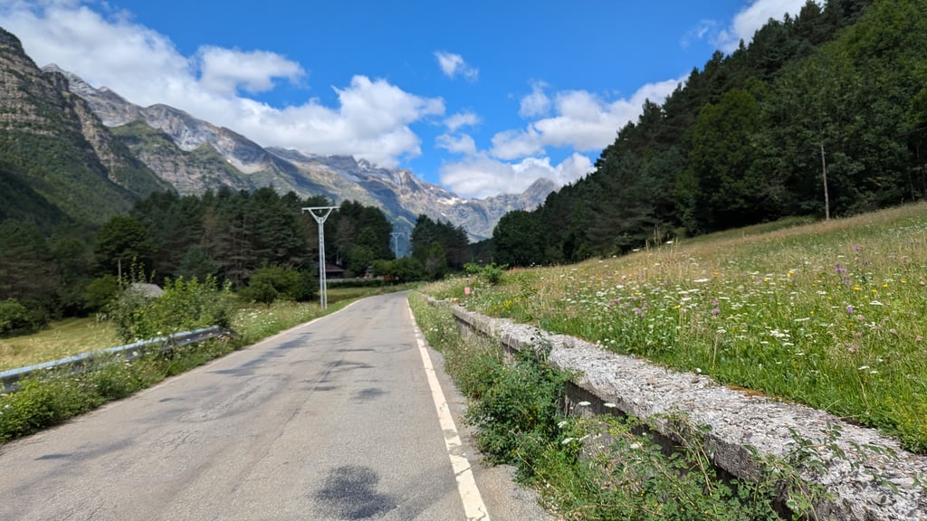
As we head towards the bottom of the valley, bordering the reservoir and the Cinca river, the views become more and more amazing: the Cinca waterfalls, the Monte Perdido massif and the Pineta Balcony rise majestically and ever closer before us as we pedal on.
The road has recently been patched up and although some potholes have been eliminated, it is somewhat uncomfortable to ride on as the road surface is not even and there are numerous bumps. It is also possible to find some loose gravel in some areas near the paint line.
It is usually a quiet road, but in summer and at weekends it is possible to find more traffic than usual. Fortunately, there is plenty of room for vehicles to overtake and you will rarely find two vehicles in front of each other.
It is advisable to do the climb to Espierba to make the route a little tougher.
Se trata de un ascenso relativamente sencillo, donde las rampas más exigentes (10-11%) las encontraremos en las primeras horquillas nada más salir de Bielsa y al llegar a Javierre. Al dejar este último, el ascenso a penas tendrá cuestas empinadas.
Conforme avanzamos hacia el fondo del valle, bordeando el embalse y el río Cinca, las vistas se harán cada vez más asombrosas: Las Cascadas del Cinca, el Macizo de Monte Perdido y el Balcón de Pineta se erigen majestuosos y cada vez más cercanos ante nosotros mientras vamos pedaleando.
La carretera ha sido parcheada recientemente y aunque se han eliminado algunos baches, es algo incómoda de recorrer ya que el firme no está igualado y hay numerosos bultos. También es posible encontrar algo de gravilla suelta en algunas zonas cerca de la línea de pintura.
Suele ser una carretera tranquila, pero en época de verano y fines de semana es posible encontrar más tráfico de lo habitual. Por suerte los vehículos tienen bastante sitio para adelantar y rara vez se encontrarán dos vehículos de frente.
Recomendable realizar la subida a Espierba para endurecer algo más la ruta.
| 7 km/h | 02:01:43 |
| 11 km/h | 01:17:27 |
| 15 km/h | 00:56:48 |
| 19 km/h | 00:44:50 |
This page is better in the app