View on map
© MapLibre | OpenStreetMap contributors
1%
2%
4%
6%
8%
10%
12%
15%
20%

Thier de l'Abbaye from Jemelle

1.5
2 reviews | Elevation profile | 2 photos
Tips nearby
Thier de l'Abbaye from Jemelle
transparant thumb
transparant thumb
transparant thumb
transparant thumb
transparant thumb
transparant thumb
Your achievable time
Calculating based on your best performances...
Relaxed
Maximum
W/kg
W/kg
W/kg
Analyse your climbing performance
Detailed insight into your climbing performance & automatically check off climbs
Based on your best performances.
Your best attempt:
Number of attempts:
Elevation profile Thier de l'Abbaye from Jemelle

Statistics

Difficulty points 63
Length 2.2 km
Average gradient 4.4%
Steepest 100 metres 10.5%
Total ascent 95 m
Feedback about this climb?
Show climbs nearby Export to GPS device

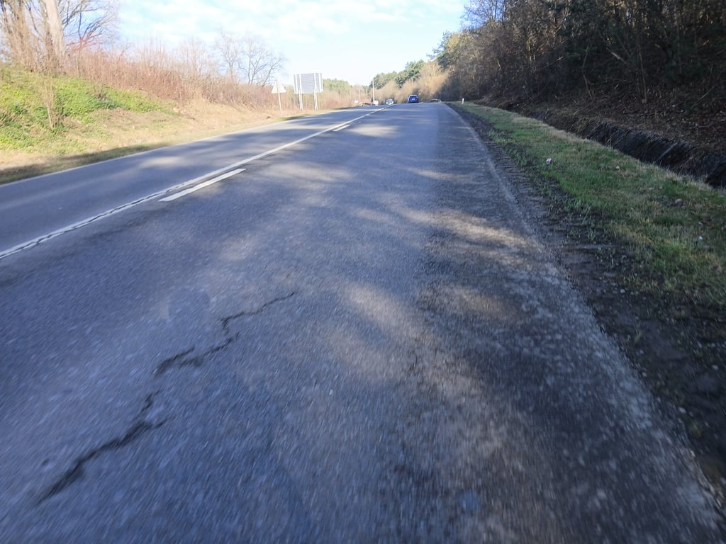
Thier de l'Abbaye from Jemelle is a climb in the region Condroz - Famenne. It is 2.2 km long and bridges 95 m of vertical ascent with an average gradient of 4.4%, resulting in a difficulty score of 63. The top of the ascent is located at 272 m above sea level. Climbfinder users shared 2 reviews of this climb and uploaded 2 photos.

Road name: Avenue de Ninove (N836)

2.0 by gaugau7
This is an automatic translation, the original language is: French.
The ascent takes place on a very large trunk road with lots of traffic, including quite a few lorries (probably because of the quarries in the area). So avoid I still gave it two stars because it's a cotacol. But otherwise one would have been enough... read more

Photos (2)

Thier de l'Abbaye from Jemelle
transparant thumb
transparant thumb
transparant thumb
transparant thumb

Your uploads (max 4)

Welcome! Please activate your account if you would like to share something. Look for the verification email in your inbox.

If you want to upload your photos, you need to create an account. It only takes 1 minute and it's completely free.

  • Receive free climbfinder goodies for your reviews & photos.
  • Create a bucket list and check off conquered climbs.
  • Add missing climbs.
Continue with GoogleContinue with Google Continue with FacebookContinue with Facebook Continue with AppleContinue with Apple Sign up with email
By signing up you agree to our terms of service and confirm that you have read our privacy & content policy.

Reviews (2)

5.0
4.0
3.0
2.0
1.0
gaugau7
3 Mo 2.0
This is an automatic translation, the original language is: French. Show original

The ascent takes place on a very large trunk road with lots of traffic, including quite a few lorries (probably because of the quarries in the area). So avoid
I still gave it two stars because it's a cotacol. But otherwise one would have been enough

Ascension qui se déroule sur une très grosse route nationale avec énormément de trafic, y compris pas mal de camions (probablement à cause des carrières dans ce coin-là). Donc à éviter
J'ai quand même mis deux étoiles pour le fait qu'il s'agit d'un cotacol. Mais sinon une seule aurait suffit

Thier de l'Abbaye from Jemelle
Dashboard
N_M
1 y 1.0 via the Climbfinder app
This is an automatic translation, the original language is: Dutch. Show original

Big track with heavy car traffic. Only doable once for the Cotacol.

Grote baan met druk autoverkeer. Enkel 1x te doen voor de Cotacol.

Dashboard

Climbing times

7 km/h 00:18:33
11 km/h 00:11:48
15 km/h 00:08:39
19 km/h 00:06:50

Road surface condition

0% 0% 0%
Based on 0 votes
Share your knowledge. What was the road condition during your ascent?

Traffic

0% 0% 0%
Based on 0 votes
Your experience counts. How much traffic did you encounter during the climb?

Frequently Asked Questions

Thier de l'Abbaye can be cycled from 3 sides. Côte du Gerny from Jemelle is the most popular side, but the summit can also be reached via Thier de l'Abbaye from Jemelle & Côte du Gerny.

You don't need special gearing for Thier de l'Abbaye from Jemelle. The slope isn't long or steep enough to require much shifting down. You can conquer this climb on power alone. However, a compact gearing system with a smallest front chainring of 34 and largest rear sprocket of 28 or 30 is always nice if you enjoy cycling uphill. This helps maintain a smooth cadence.

Thier de l'Abbaye from Jemelle falls into the 5th category. With good fitness, you can ride it up with speed and power. If you have less training, shift down and climb smoothly.

Thier de l'Abbaye from Jemelle is 2.2 km long.

The average gradient of Thier de l'Abbaye from Jemelle is 4.4%.

Thier de l'Abbaye from Jemelle has a steepest segment with an average gradient of 10.5%.

The summit of Thier de l'Abbaye from Jemelle is at 272 m.

At a slow pace of 7 km/h, it takes about 00:18:33 to climb Thier de l'Abbaye from Jemelle. At 11 km/h the time is 00:11:48, and at 15 km/h 00:08:39. For the fastest cyclists, 00:06:50 is an achievable time.

Thier de l'Abbaye from Jemelle is located in the region Condroz - Famenne in Belgium.

This page is better in the app

Climbfinder app
Climbfinder
(Free)
Open