View on map
© MapLibre | OpenStreetMap contributors
1%
2%
4%
6%
8%
10%
12%
15%
20%

Puerto de Bonansa from La Puebla de Roda

3.0
1 review/story | Elevation profile | 2 photos
Tips nearby
Puerto de Bonansa from La Puebla de Roda
transparant thumb
transparant thumb
transparant thumb
transparant thumb
transparant thumb
transparant thumb
Your achievable time
Calculating based on your best performances...
Relaxed
Maximum
W/kg
W/kg
W/kg
Analyse your climbing performance
Detailed insight into your climbing performance & automatically check off climbs
Based on your best performances.
Your best attempt:
Number of attempts:
Elevation profile Puerto de Bonansa from La Puebla de Roda

Statistics

Difficulty points 250
Length 15.4 km
Average gradient 3.4%
Steepest 100 metres 8.3%
Total ascent 524 m

Short recap

1 hairpin turn
#91 toughest climb of Aragon
#58 most elevation gain of Aragon
#37 longest climb of Aragon
Feedback about this climb?
Show climbs nearby Export to GPS device

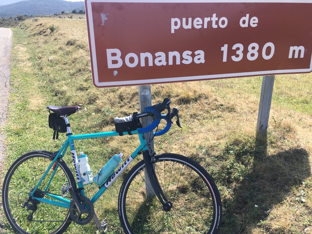
Puerto de Bonansa from La Puebla de Roda is a climb in the region Spanish Pyrenees. It is 15.4 km long and bridges 524 m of vertical ascent with an average gradient of 3.4%, resulting in a difficulty score of 250. The top of the ascent is located at 1365 m above sea level. Climbfinder users shared 1 review/story of this climb and uploaded 2 photos.

Road name: A-1605

3.0 by aqcycling
This is an automatic translation, the original language is: Dutch.
Another one of those's typical Spanish Pyrenean roads. A nice tight tarmac road through the valley - but very quiet and you almost wonder where such a big wide road's supposed to go then. Only when you leave the river does the road get a bit narrower and you get the feeling that you are climbing a mountain pass. By the way, the last few hundred metres are very open, so with a bit of bad luck, you will have a lot of wind up there. ... read more

Photos (2)

Puerto de Bonansa from La Puebla de Roda
transparant thumb
transparant thumb
transparant thumb
transparant thumb

Your uploads (max 4)

Welcome! Please activate your account if you would like to share something. Look for the verification email in your inbox.

If you want to upload your photos, you need to create an account. It only takes 1 minute and it's completely free.

  • Receive free climbfinder goodies for your reviews & photos.
  • Create a bucket list and check off conquered climbs.
  • Add missing climbs.
Continue with GoogleContinue with Google Continue with FacebookContinue with Facebook Continue with AppleContinue with Apple Sign up with email
By signing up you agree to our terms of service and confirm that you have read our privacy & content policy.

Reviews (1)

5.0
4.0
3.0
2.0
1.0
aqcycling
2 y 3.0
This is an automatic translation, the original language is: Dutch. Show original

Another one of those's typical Spanish Pyrenean roads. A nice tight tarmac road through the valley - but very quiet and you almost wonder where such a big wide road's supposed to go then. Only when you leave the river does the road get a bit narrower and you get the feeling that you are climbing a mountain pass. By the way, the last few hundred metres are very open, so with a bit of bad luck, you will have a lot of wind up there.

Weer zo'n typische Spaanse Pyreneeënweg. Een mooie strakke asfaltbaan door het dal - maar heel stil en je vraagt je bijna af waar zo'n grote brede weg dan heen moet gaan. Pas als je de rivier verlaat wordt de weg wat smaller en krijg je het gevoel dat je een bergpas aan het beklimmen bent. De laatste paar honderd meter is overigens erg open, dus met een beetje pech heb je daar dan flink de wind op de kop.

Dashboard

Climbing times

7 km/h 02:11:58
11 km/h 01:23:59
15 km/h 01:01:35
19 km/h 00:48:37

Road surface condition

0% 0% 0%
Based on 0 votes
Share your knowledge. What was the road condition during your ascent?

Traffic

0% 0% 0%
Based on 0 votes
Your experience counts. How much traffic did you encounter during the climb?

Frequently Asked Questions

Puerto de Bonansa can be cycled from 2 sides. Puerto de Bonansa from La Puebla de Roda is the most popular side, but the summit can also be reached via Puerto de Bonansa via Bonansa.

You don't need special gearing for Puerto de Bonansa from La Puebla de Roda. The slope isn't long or steep enough to require much shifting down. You can conquer this climb on power alone. However, a compact gearing system with a smallest front chainring of 34 and largest rear sprocket of 28 or 30 is always nice if you enjoy cycling uphill. This helps maintain a smooth cadence.

Puerto de Bonansa from La Puebla de Roda is a 3rd-category climb. Almost anyone can handle this climb, as long as you have a bike with climbing gears. If you have little training, you will probably need to shift down significantly. For experienced riders, Puerto de Bonansa from La Puebla de Roda is not a problem.

Puerto de Bonansa from La Puebla de Roda is 15.4 km long.

The average gradient of Puerto de Bonansa from La Puebla de Roda is 3.4%.

Puerto de Bonansa from La Puebla de Roda has a steepest segment with an average gradient of 8.3%.

The summit of Puerto de Bonansa from La Puebla de Roda is at 1365 m.

At a slow pace of 7 km/h, it takes about 02:11:58 to climb Puerto de Bonansa from La Puebla de Roda. At 11 km/h the time is 01:23:59, and at 15 km/h 01:01:35. For the fastest cyclists, 00:48:37 is an achievable time.

Puerto de Bonansa from La Puebla de Roda is located in the region Aragon in Spain.

This page is better in the app

Climbfinder app
Climbfinder
(Free)
Open