View on map
© MapLibre | OpenStreetMap contributors
1%
2%
4%
6%
8%
10%
12%
15%
20%

Monti from Rondinera

3.0
1 review/story | Elevation profile | 5 photos
Tips nearby
Monti from Rondinera
transparant thumb
transparant thumb
transparant thumb
Your achievable time
Calculating based on your best performances...
Relaxed
Maximum
W/kg
W/kg
W/kg
Analyse your climbing performance
Detailed insight into your climbing performance & automatically check off climbs
Based on your best performances.
Your best attempt:
Number of attempts:
Elevation profile Monti from Rondinera

Statistics

Difficulty points 599
Length 9.2 km
Average gradient 7.2%
Steepest 100 metres 16.8%
Total ascent 660 m

Short recap

Beautiful scenery
11 hairpin turns
#28 toughest climb of Bergamo
#33 most elevation gain of Bergamo
#39 longest climb of Bergamo
#82 average steepest climb of Bergamo
Feedback about this climb?
Show climbs nearby Export to GPS device

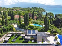
Monti from Rondinera is a climb in the region Bergamo. It is 9.2 km long and bridges 660 m of vertical ascent with an average gradient of 7.2%, resulting in a difficulty score of 599. The top of the ascent is located at 836 m above sea level. Climbfinder users shared 1 review/story of this climb and uploaded 5 photos.

Road names: Via del Corno, Via San Pietro, Via Giuseppe Verdi, Via San Gaudenzio & Via Cavour

This is an automatic translation, the original language is: Italian.
Quite a tough climb, it never lets up except at San Vigilio where there is an excellent bar and restaurant. After the first km there is only one fountain on the right near the war memorial. Excellent asphalt. The maximum peak read by my Garmin was 15% for a few dozen metres. Fairly sunny. Almost no traffic. More bikes than cars.... read more

Photos (5)

Monti from Rondinera
transparant thumb

Your uploads (max 4)

Welcome! Please activate your account if you would like to share something. Look for the verification email in your inbox.

If you want to upload your photos, you need to create an account. It only takes 1 minute and it's completely free.

  • Receive free climbfinder goodies for your reviews & photos.
  • Create a bucket list and check off conquered climbs.
  • Add missing climbs.
Continue with GoogleContinue with Google Continue with FacebookContinue with Facebook Continue with AppleContinue with Apple Sign up with email
By signing up you agree to our terms of service and confirm that you have read our privacy & content policy.

Reviews (1)

5.0
4.0
3.0
2.0
1.0
MauroBresciani
1 y 3.0
This is an automatic translation, the original language is: Italian. Show original

Quite a tough climb, it never lets up except at San Vigilio where there is an excellent bar and restaurant. After the first km there is only one fountain on the right near the war memorial. Excellent asphalt. The maximum peak read by my Garmin was 15% for a few dozen metres. Fairly sunny. Almost no traffic. More bikes than cars.

Salita abbastanza tosta, non molla mai se non a San Vigilio dove c'è un ottimo bar ristorante. Dopo il primo km si trova unica fontanella sulla destra in prossimità del monumento ai caduti della guerra. Asfalto ottimo. Il picco massimo letto dal mio Garmin è stato 15% per poche decine di metri. Abbastanza assolata. Traffico pressoché nullo. Più bici che auto.

Dashboard

Climbing times

7 km/h 01:18:41
11 km/h 00:50:04
15 km/h 00:36:43
19 km/h 00:28:59

Road surface condition

100% 0% 0%
Based on 1 vote
Share your knowledge. What was the road condition during your ascent?

Traffic

100% 0% 0%
Based on 1 vote
Your experience counts. How much traffic did you encounter during the climb?

Frequently Asked Questions

Monti can be cycled from 2 sides. Monti from Rondinera is the most popular side, but the summit can also be reached via Monti from Montecchio.

Monti from Rondinera is a challenging ascent. For this type of climbing, we recommend mountain gearing, specifically a compact system. This means a small front chainring of 34 teeth, combined with a rear cassette where, depending on your level, strength, and experience, you choose a sprocket with 30, 32, or even 34 teeth. Remember that a smooth cadence is always more efficient!

Monti from Rondinera is a serious climb and falls into the 2nd category. With a good basic fitness level, even without much cycling experience, you can complete this climb just fine. However, a bike with climbing gears is a must. Without experience or training, it will be really tough – but that’s part of the challenge!

Monti from Rondinera is 9.2 km long.

The average gradient of Monti from Rondinera is 7.2%.

Monti from Rondinera has a steepest segment with an average gradient of 16.8%.

The summit of Monti from Rondinera is at 836 m.

At a slow pace of 7 km/h, it takes about 01:18:41 to climb Monti from Rondinera. At 11 km/h the time is 00:50:04, and at 15 km/h 00:36:43. For the fastest cyclists, 00:28:59 is an achievable time.

Monti from Rondinera is located in the region Bergamo in Italy.

This page is better in the app

Climbfinder app
Climbfinder
(Free)
Open