View on map
© MapLibre | OpenStreetMap contributors
1%
2%
4%
6%
8%
10%
12%
15%
20%

Louis de Meesterstraat

3.0
4 reviews | Elevation profile | 1 photo
Tips nearby
Louis de Meesterstraat
transparant thumb
transparant thumb
transparant thumb
transparant thumb
transparant thumb
transparant thumb
transparant thumb
Your achievable time
Calculating based on your best performances...
Relaxed
Maximum
W/kg
W/kg
W/kg
Analyse your climbing performance
Detailed insight into your climbing performance & automatically check off climbs
Based on your best performances.
Your best attempt:
Number of attempts:
Elevation profile Louis de Meesterstraat

Statistics

Difficulty points 10
Length 0.5 km
Average gradient 4.2%
Steepest 100 metres 6.6%
Total ascent 20 m
Feedback about this climb?
Show climbs nearby Export to GPS device

Louis de Meesterstraat is a climb in the region Flemish Ardennes. It is 0.5 km long and bridges 20 m of vertical ascent with an average gradient of 4.2%, resulting in a difficulty score of 10. The top of the ascent is located at 30 m above sea level. Climbfinder users shared 4 reviews of this climb and uploaded 1 photo.

Road names: Louis de Meesterstraat & Grenadierslaan

3.0 by Man
This is an automatic translation, the original language is: Dutch.
The longest road to Semmerzake if you come from the north, so also the easiest. Doesn't get flatter towards the end though so good dosage is the message.... read more

Photos (1)

Louis de Meesterstraat
transparant thumb
transparant thumb
transparant thumb
transparant thumb
transparant thumb

Your uploads (max 4)

Welcome! Please activate your account if you would like to share something. Look for the verification email in your inbox.

If you want to upload your photos, you need to create an account. It only takes 1 minute and it's completely free.

  • Receive free climbfinder goodies for your reviews & photos.
  • Create a bucket list and check off conquered climbs.
  • Add missing climbs.
Continue with GoogleContinue with Google Continue with FacebookContinue with Facebook Continue with AppleContinue with Apple Sign up with email
By signing up you agree to our terms of service and confirm that you have read our privacy & content policy.

Reviews (4)

5.0
4.0
3.0
2.0
1.0
Man
5 Mo 3.0
This is an automatic translation, the original language is: Dutch. Show original

The longest road to Semmerzake if you come from the north, so also the easiest. Doesn't get flatter towards the end though so good dosage is the message.

De langste weg om Semmerzake op te rijden als je uit het noorden komt, dus ook de makkelijkste. Wordt wel niet vlakker naar het einde dus goed doseren is de boodschap.

Dashboard
BrechtO
1 y 3.0
This is an automatic translation, the original language is: Dutch. Show original

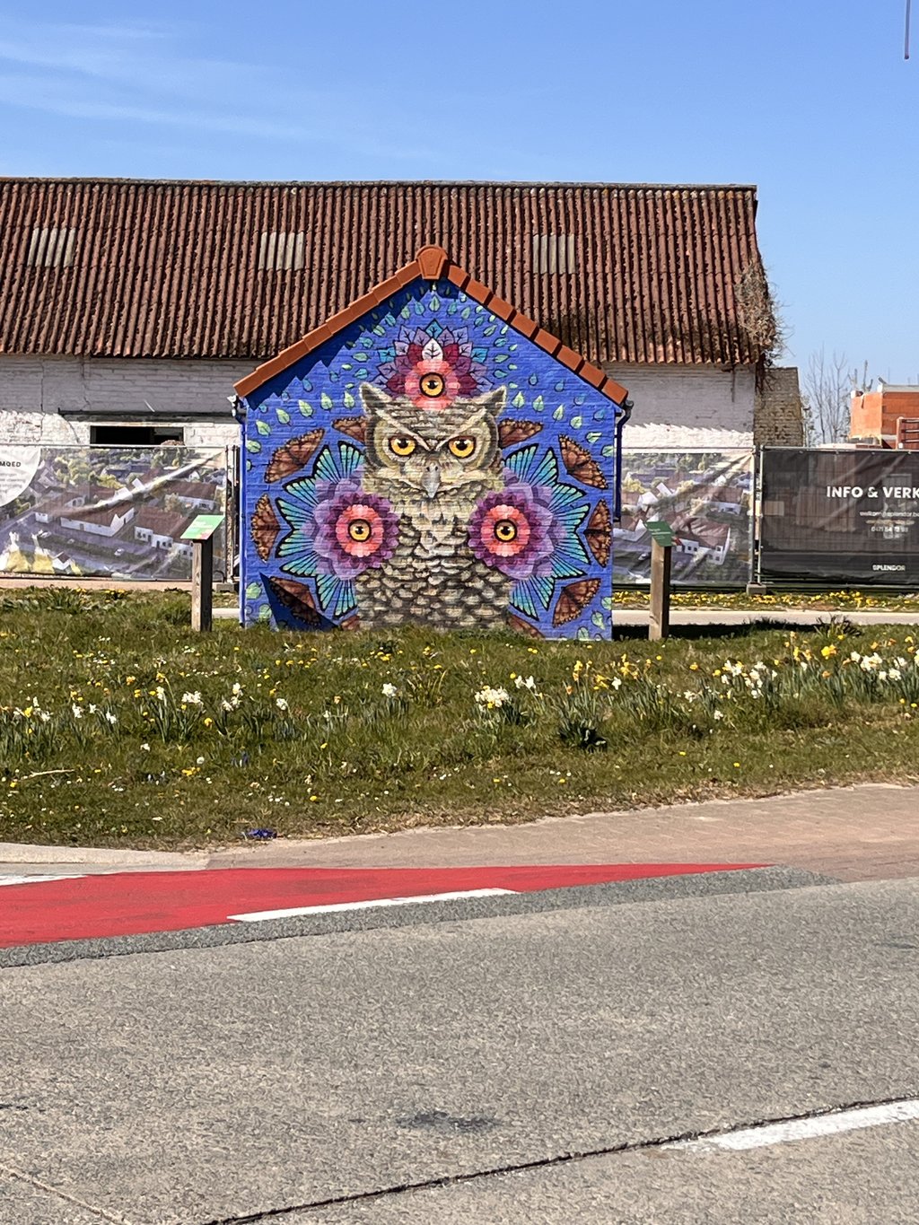
Another pleasant climb to do! Was tougher than expected! At the end you get another nice wall painting!

Nog een aangename klim om te doen! Was zwaarder dan verwacht! Op het einde krijg je nog een mooi muurschilderij!

Louis de Meesterstraat
Dashboard
Pieter394
1 y 3.0
This is an automatic translation, the original language is: Dutch. Show original

The gateway to the Flemish Ardennes: from here you can then continue towards Gavere and Dikkelvenne to enter the Flemish Ardennes. Pleasant little climb, between the houses, tougher than expected, as it seemed only a very limited plateau from afar. Beware of the many sewer covers and some potholes in the road.

De poort van de Vlaamse Ardennen: langs hier kan je vervolgens doorsteken richting Gavere en Dikkelvenne om de Vlaamse Ardennen in te rijden. Plezant klimmetje, tussen de huizen, zwaarder dan verwacht, want het leek vanuit de verte maar een zeer beperkt plateautje. Opgelet van de vele riooldeksels en wat putten in de weg.

Dashboard
Seba
4 y 3.0
This is an automatic translation, the original language is: Dutch. Show original

Nice little climb to blast away at. Especially useful to cross here to Gavere if you are tired of riding along the Scheldt and would rather make some altitude metres.

Leuk klimmetje om volop op te knallen. Vooral handig om langs hier door te steken naar Gavere als je het beu bent om langs de Schelde te rijden en liever al wat hoogtemeters maakt.

Dashboard

Climbing times

7 km/h 00:04:02
11 km/h 00:02:34
15 km/h 00:01:53
19 km/h 00:01:29

Road surface condition

50% 50% 0%
Based on 2 votes
Share your knowledge. What was the road condition during your ascent?

Traffic

100% 0% 0%
Based on 2 votes
Your experience counts. How much traffic did you encounter during the climb?

Frequently Asked Questions

You don't need special gearing for Louis de Meesterstraat. The slope isn't long or steep enough to require much shifting down. You can conquer this climb on power alone. However, a compact gearing system with a smallest front chainring of 34 and largest rear sprocket of 28 or 30 is always nice if you enjoy cycling uphill. This helps maintain a smooth cadence.

Louis de Meesterstraat is not tough enough to be assigned a mountain category. This means that even untrained cyclists can reach the top without any problems on this climb.

Louis de Meesterstraat is 0.5 km long.

The average gradient of Louis de Meesterstraat is 4.2%.

Louis de Meesterstraat has a steepest segment with an average gradient of 6.6%.

The summit of Louis de Meesterstraat is at 30 m.

At a slow pace of 7 km/h, it takes about 00:04:02 to climb Louis de Meesterstraat. At 11 km/h the time is 00:02:34, and at 15 km/h 00:01:53. For the fastest cyclists, 00:01:29 is an achievable time.

Louis de Meesterstraat is located in the region East Flanders in Belgium.

This page is better in the app

Climbfinder app
Climbfinder
(Free)
Open