Tips nearby


| Hidden gem |
| 6 hairpin turns |
| #33 toughest climb of La Maurienne |
| #47 most elevation gain of La Maurienne |
| #56 longest climb of La Maurienne |
| #15 average steepest climb of Savoie |
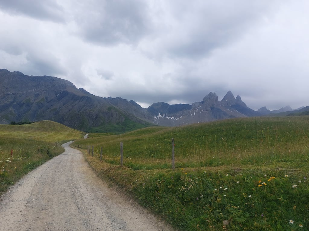
Coulouvreuse / Montée aux Aiguilles d’Arves is a climb in the region La Maurienne. It is 7.2 km long and bridges 696 m of vertical ascent with an average gradient of 9.7%, resulting in a difficulty score of 695. The top of the ascent is located at 1912 m above sea level. Climbfinder users shared 4 reviews of this climb and uploaded 10 photos.
Road name: D80A
4.0 by Niels1987This is an automatic translation, the original language is: Dutch.A very beautiful and tough climb. In principle, it is even harder than indicated here, because you reach the foot of it only if you first do the first 15 kilometers of the Croix de Fer from Saint Jean de Maurienne or another alternative is to first do the Col du Mollard and then descend a few kilometers. I did the first variant and then you have 22 kilometers with just over 1300 altimeters. Because there are 2 pieces of descent in it, you actually climb this in 17 kilometers, which means that yo... read more

Welcome! Please activate your account if you would like to share something. Look for the verification email in your inbox.
If you want to upload your photos, you need to create an account. It only takes 1 minute and it's completely free.
Very nice climb that is shorter but steeper than the rest in this area. Equally 9 to 10% along the whole length and if you have a gravel bike you can continue on gravel for a little bit after the top. Very bad road surface, the further the worse, and because of this also a dangerous descent if you have to go back. The views here are super nice though. Definitely worth it for this alone!
Heel leuke klim die korter maar steiler is dan de rest in deze omgeving. Gelijkmatig 9 tot 10% over de hele lengte en als je een gravelfiets hebt kan je nog een klein stukje na de top over gravel verder. Zeer slecht wegdek, hoe verder hoe slechter, en hierdoor ook een gevaarlijke afdaling als je terug moet. De uitzichten zijn hier wel super mooi. Enkel al hiervoor zeker de moeite!
Without Climbfinder, I would never have left the road at the end of the Col du Mollard descent (towards Croix de Fer) for this hidden dead-end gem!
It was for me (June 2023) at the start, briefly queued by a herd of cows on the narrow tarmac stepping towards their pasture. You continuously cycle through the steeply climbing village of Montrond with its little church and a few cottages, before passing the last inhabited farms in Le Chalmieu.
Afterwards it is pure nature with green alpine meadows full of flowers and a skyline of snow-covered 3000+ mountain peaks with the famous three-part rock formation Aiguilles d'Arves that occasionally peeked through the clouds and made you forget the double-digit percentages.
There is no traffic,not even cyclists. The tarmac gets worse the higher you climb which urges caution especially on the descent.
Top is desolate car park with transmitter mast where asphalt stops and turns to gravel.
Thanks to Climbfinder, this also became my starting point for two fantastic mountain trips with mountain boots and backpack.
Literally and figuratively breathtaking cycling route to the French "Tre Cime"!!!
The max for me as a mountain lover!
Zonder Climbfinder zou ik nooit op het einde van de Col du Mollard afdaling (richting Croix de Fer) de weg links verlaten voor deze verborgen doodlopende parel!
Het was voor mij (Juni 2023) bij de start, even filevorming door een kudde koeien op het smalle asfalt stapvoets naar hun weide. Je fietst continu steil klimmend dorpje Montrond door met kerkje en enkele huisjes om even verder in Le Chalmieu de laatst bewoonde boerderijen te passeren.
Nadien is het puur natuur met groene alpenweides vol met bloemen en een skyline van besneeuwde 3000+ bergtoppen met de beroemde driedelige rotsformatie Aiguilles d'Arves die af en toe door de wolken kwam piepen en je de dubbele cijfers percentages doen vergeten.
Er is geen verkeer,zelfs geen fietsers. Het asfalt wordt slechter naarmate je hoger klimt wat vooral in de afdaling tot voorzichtigheid aanmaant.
Top is desolate parking met zendmast alwaar asfalt stopt en overgaat in gravel.
Dankzij Climbfinder werd dit ook mijn vertrekpunt voor twee fantastische bergtochten met bergschoenen en rugzak.
Letterlijk en figuurlijk adembenemende fietsroute naar de Franse "Tre Cime"!!!
De max voor mij als bergliefhebber!
7km full on from start to finish! Really burnt out at the end but what a feeling of accomplishment to have reached the top, and besides the view is also a great reward!
7km à bloc du début à la fin ! Vraiment cramé à l'arrivée mais quel sentiment d'accomplissement d'avoir atteint le sommet, et d'ailleurs la vue est aussi une belle récompense !
A very beautiful and tough climb. In principle, it is even harder than indicated here, because you reach the foot of it only if you first do the first 15 kilometers of the Croix de Fer from Saint Jean de Maurienne or another alternative is to first do the Col du Mollard and then descend a few kilometers. I did the first variant and then you have 22 kilometers with just over 1300 altimeters. Because there are 2 pieces of descent in it, you actually climb this in 17 kilometers, which means that you often see percentages of 8-9-10 percent. The road surface is getting less when you take the turnoff to le chalmieu, but the scenery is getting better. Especially the end is beautiful, with a view on the Aiguille d' Arves of 3500 m high.
Een hele mooie en zware klim. In principe is deze nog veel zwaarder dan hier aangegeven, want je bereikt de voet er van pas als je eerst de eerste 15 kilometer van de Croix de Fer vanuit Saint Jean de Maurienne doet of een ander alternatief is door eerst de Col du Mollard te doen en daarna een paar kilometer af te dalen. Ik deed de eerste variant en dan heb je 22 kilometer met iets meer dan 1300 hoogtemeters. Omdat er 2 stukken afdaling in zitten klim je dit eigenlijk in 17 kilometer, wat betekent dat je vaak percentages van 8-9-10 procent ziet. Het wegdek word minder wanneer je de afslag naar le chalmieu neemt, maar het landschap steeds mooier. Vooral het einde is mooi, met zicht op de Aiguille d' Arves van 3500 m hoog.
| 7 km/h | 01:01:17 |
| 11 km/h | 00:39:00 |
| 15 km/h | 00:28:36 |
| 19 km/h | 00:22:34 |
This page is better in the app