Tips nearby


| 3 hairpin turns |
| #72 toughest climb of Upper Rhine |
| #73 most elevation gain of Upper Rhine |
| #76 longest climb of Upper Rhine |
| #68 average steepest climb of Upper Rhine |
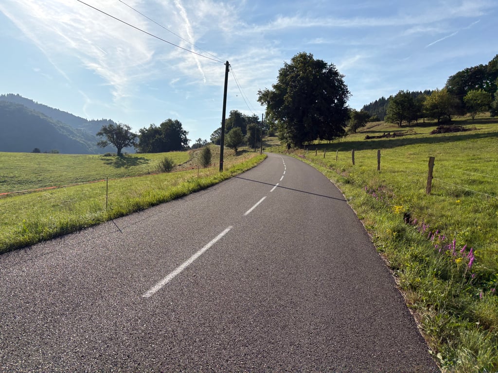
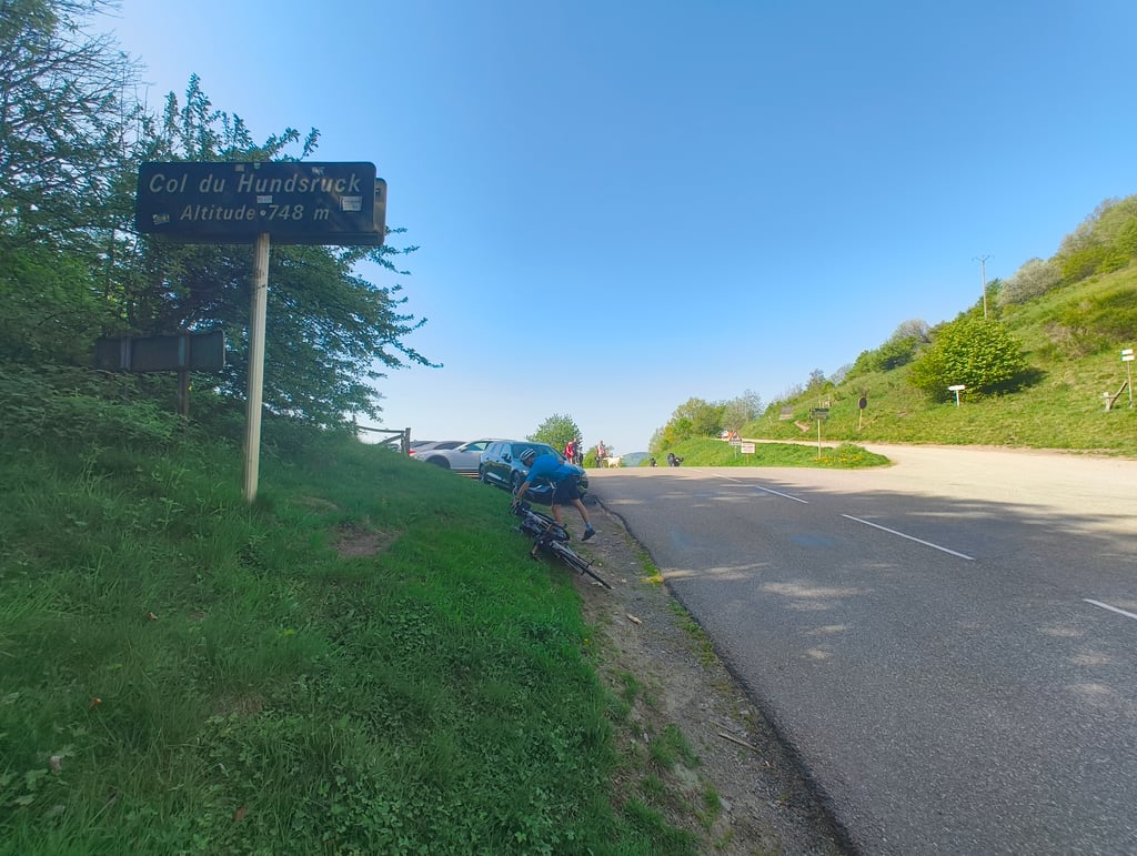
Col du Hundsruck from Bitschwiller-lès-Thann is a climb in the region Upper Rhine. It is 5.9 km long and bridges 386 m of vertical ascent with an average gradient of 6.6%, resulting in a difficulty score of 290. The top of the ascent is located at 746 m above sea level. Climbfinder users shared 14 reviews of this climb and uploaded 22 photos.
Road name: Route de Joffre / D1484
3.0 by TitouanThis is an automatic translation, the original language is: French.An easy climb, to say the least... No major difficulties. A practical climb for changing valleys (grand ballon, Ballon d'Alsace). That said, be careful on the descent, which has some cobbled sections as you pass through towns.... read more
Welcome! Please activate your account if you would like to share something. Look for the verification email in your inbox.
If you want to upload your photos, you need to create an account. It only takes 1 minute and it's completely free.
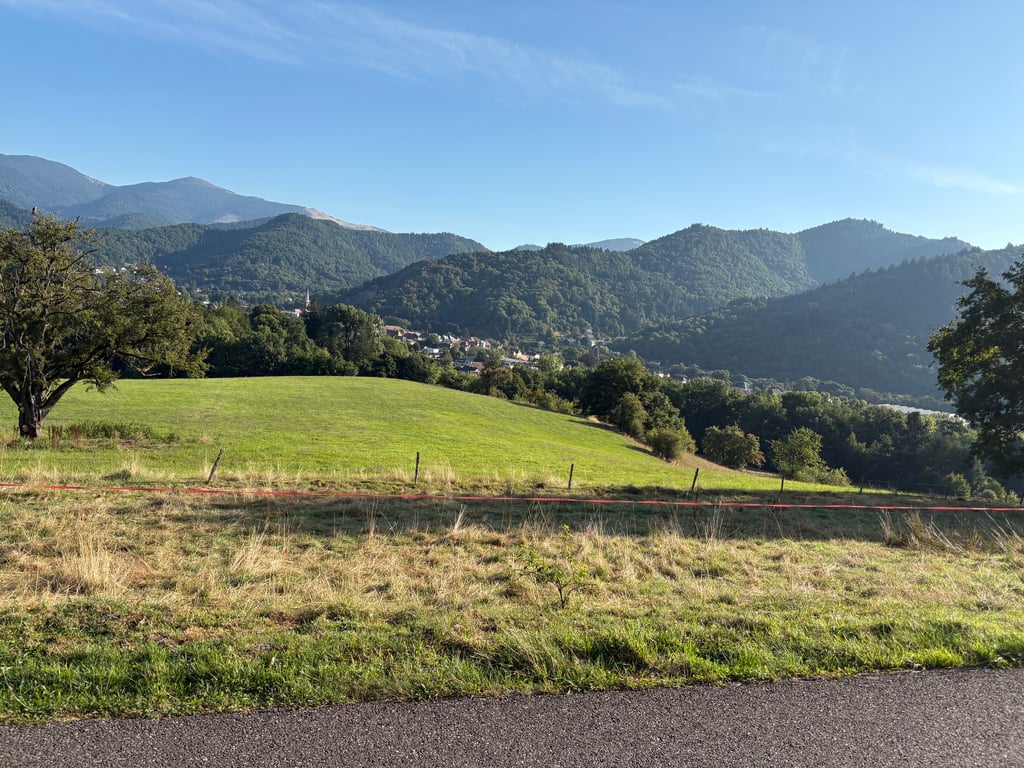
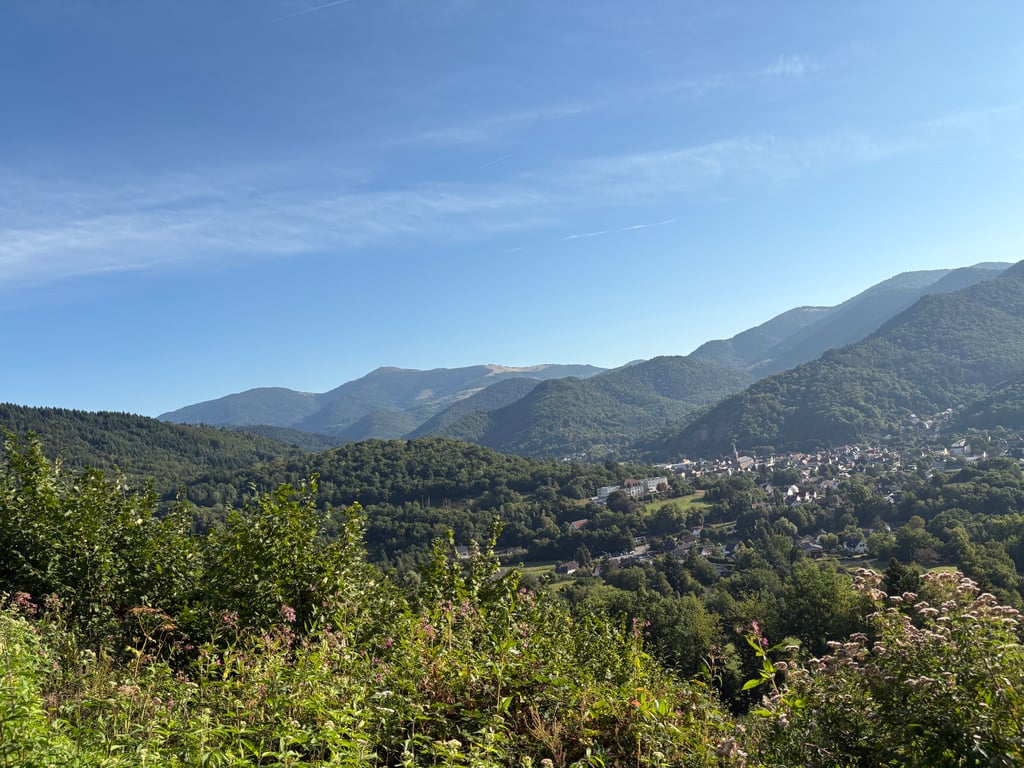
Superb climb, lovely quiet early-morning climb on perfect tarmac. Nice views over the valley at the start. The devil is in the tail here. So it takes some effort to get to the top!
Schiterrende klim, heerlijk rustig klimmen in de vroege morgen op perfect asfalt. In het begin mooi uitzicht over het dal. Het venijn zit hem hier in de staart. Even doorbijten tot de top dus!
Beautiful quiet Vosges Col at a solid climbing percentage. Moreover, you can ride through and descend along the other side along equally handsome, quiet good roads.
Prachtige rustige Vogezencol aan een stevig klimpercentage. Bovendien kan doorrijden en langs de andere kant afdalen langs eveneens knappe, rustige goede wegen.
Quite an affordable climb. Up to the crossroads with the forest road coming from Thann, the gradient is manageable (just one short section at 10% and a flat area). After that, it's a different story with frequent crossings above 10% (max 12-13%).
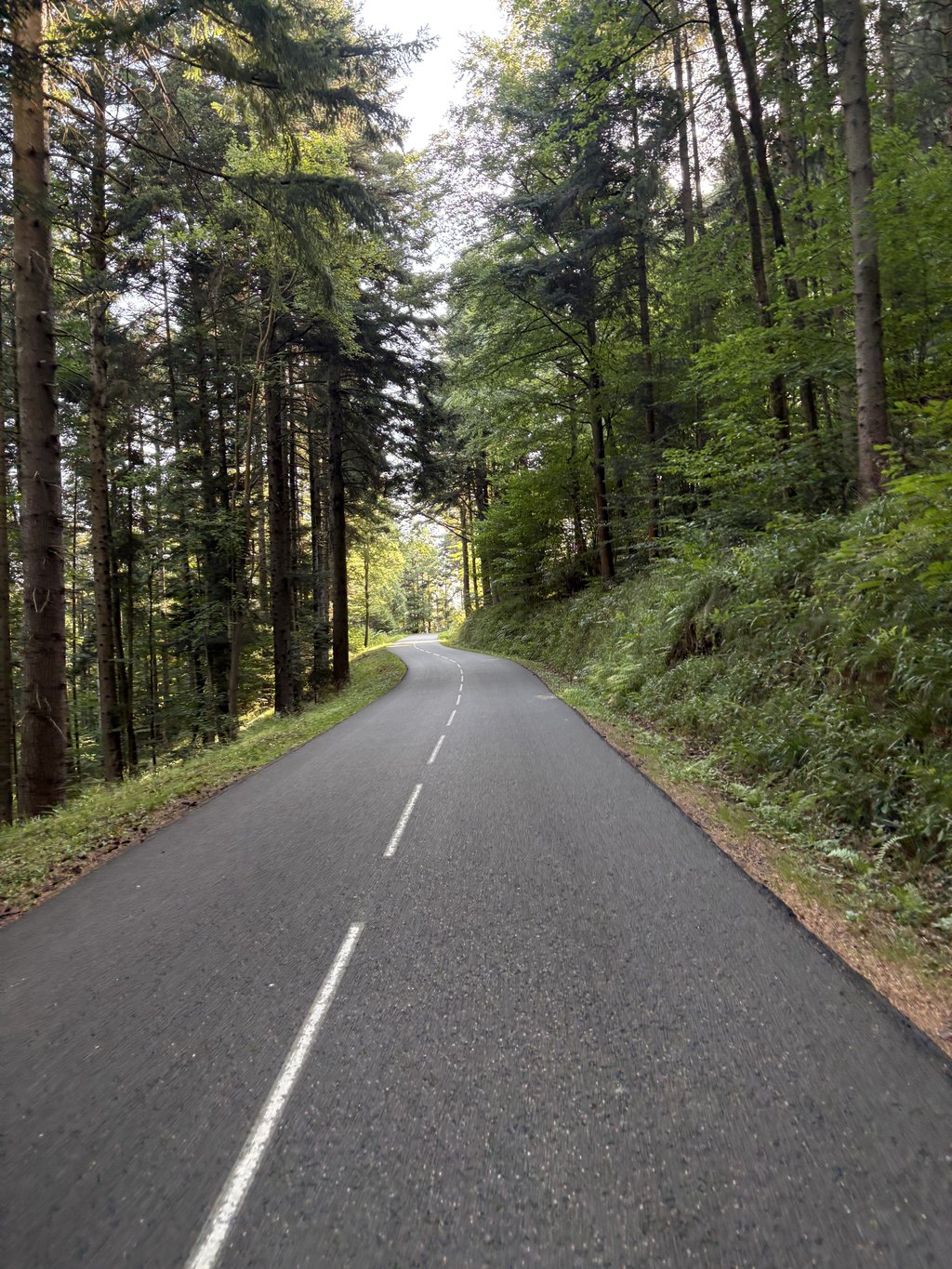
Little/no traffic on this climb with perfect tarmac from start to finish.
Ascension assez abordable. Jusqu'au carrefour avec la route forestière venant de Thann, la pente est gérable (un seul court passage à 10% et un replat). Après, c'est une autre histoire avec des passages fréquents au-dessus de 10% (max 12-13%).
Peu/pas de circulation sur cette montée avec un bitume parfait du début à la fin.
One of m'n favourite climbs in the region. Lovely road surface, nice and quiet, and mostly doable percentages. A bit before the summit, it goes up steeply. The only thing it lacks is a nice view
Een van m'n favoriete beklimmingen in de regio. Heerlijk wegdek, lekker rustig en voornamelijk percentages die goed te doen zijn. Stukje voor de top loopt het nog venijnig omhoog. Het enige wat ie mist is een mooi uitzicht
An easy climb, to say the least... No major difficulties. A practical climb for changing valleys (grand ballon, Ballon d'Alsace). That said, be careful on the descent, which has some cobbled sections as you pass through towns.
Ascension pour le moins facile… Aucune difficulté majeure. Ascension pratique pour changer de vallée (grand ballon --> Ballon d'Alsace). Ceci dit, attention à la descente qui présente, lors de la traversée de localités certains passages en pavé.
A short climb that's very useful if you want to finish a long uphill section (after the Grand Ballon).
Montée courte très utile lorsque l'on souhaite finir une longue sortie de côte. (Après le grand Ballon).
It is a nice quiet climb that is not too difficult. You can enjoy the beautiful nature while cycling uphill.
Het is een mooie rustige beklimming die niet al te moeilijk is. Men kan er rustig genieten van de mooie natuur als men bergop fiets.
June 2019. Had read here or there that you can also from Thann via forest road. But unfortunately the tarmac here very bad, from the top descended to Bitschwiller-lès-Thann via provincial road D1484 not busy here but good tarmac with at laats beautiful view of the Grand Ballon. There we go now (the most beautiful in the Vosges first forest and the last 4 A 5 km open area) little Mont Ventoux but then green.
Juni 2019. Had hier of daar gelezen dat je ook vanuit Thann via bosweg kunt. Maar helaas het asfalt hier heel slecht, vanaf de top afgedaald naar Bitschwiller-lès-Thann via provinciale weg D1484 niet druk hier wel prima asfalt met op laats mooi uitzicht op de Grand Ballon. Daar gaan we nu naar toe (de mooiste in de Vogezen eerst bos en de laatste 4 A 5 km open gebied) beetje Mont Ventoux maar dan groen.
The climb from the other side is nicer, because then you can descend on the best piece of tarmac in France I think. Phenomenal tarmac and great curves through a forest. The climb from Masevaux also has a nice part in between. After the descent you arrive in Bitschwiller-lès-Thann. From here it's only a few kilometers to Willier sur Thur, where you can climb the biggest obstacle of the Vosges: the Grand Ballon! Then you have a nice tour with many altimeters and great views!
De klim vanaf de andere kant is mooier, want dan kan je afdalen op het beste stukje asfalt van Frankrijk denk ik. Fenomenaal asfalt en geweldige bochten door een bos. De klim vanuit Masevaux heeft ook een lekker tussenstuk. Na de afdaling kom je aan in Bitschwiller-lès-Thann. Vanaf hier is het enkele kilometers tot Willier sur Thur, waar je het huzarenstukje van de Vogezen kan beklimmen: de Grand Ballon! Dan heb je een mooi rondje met veel hoogtemeters en geweldige uitzichten!
Part of the tour in 2019, best bit of tarmac in France. Climbs wonderfully and fairly evenly, except for a small steeper section just past the half way point.
Super quiet, fantastic scenery and you can go straight into the descent (because there's not that much to do at the top)!
In 2019 onderdeel van de tour, beste stukje asfalt van Frankrijk. Klimt heerlijk en vrij gelijk, op een klein steiler stukje net voorbij de helft.
Super rustig, fantastische natuur en je kan gelijk de afdaling in (want er is niet zo veel te doen boven)!
Man what a beautiful climb, good road and beautiful nature, you're almost all the time in a beautiful forest, you sometimes feel like the Ardennes! Although this is not such a famous climb and seems not so difficult based on the figures, but they say certainly not everything, a warning man is worth 2!
Man wat een mooie klim, goed wegdek en prachtige natuur, je zit bijna hele tijd in een prachtig bos, je want je soms zelfs in de Ardennen! Al is dit niet zo'n bekende klim en lijkt hij niet zo moeilijk op basis van de cijfers, maar die zeggen zeker niet alles, een gewaarschuwd man is er 2 waard!
Seems relatively easy based on the numbers but the climb feels different. Because you're in the woods the whole time, it also feels like you're not going forward. From Thann certainly not the most beautiful climb, but the descent on the other side is definitely worth it. At the top it can be quite busy (cars and buses)
Lijkt op basis van de cijfers relatief eenvoudig maar de klim voelt toch anders aan. Doordat je de hele tijd in het bos rijdt, voelt het ook aan alsof je niet vooruit gaat. Vanuit Thann zeker niet de mooiste klim, maar de afdaling aan de andere kant is zeker de moeite. Boven kan het redelijk druk zijn (auto's en bussen)
A steep climb with some short stretches for recovery. Road in good condition.
Pittige beklimming met af en toe een kort stukje voor recuperatie. Wegdek in goede staat.
Nice climb that feels spicier than you read from the profile.
Few views along the way, therefore much shelter.
But once at the top (coming from Tann) suddenly a fantastic view over the valley unfolds!
Mooie klim die pittiger aanvoelt dan je uit het profiel leest.
Weinig uitzicht onderweg, daarom wel veel beschutting.
Maar eenmaal boven (komende vanuit Tann) ontpopt zich plots een fantastisch vergezicht over het dal!
| 7 km/h | 00:50:17 |
| 11 km/h | 00:32:00 |
| 15 km/h | 00:23:28 |
| 19 km/h | 00:18:31 |
This page is better in the app