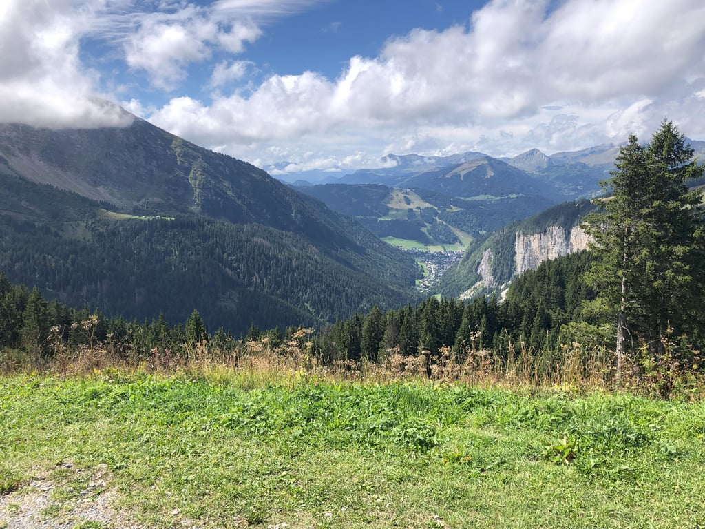
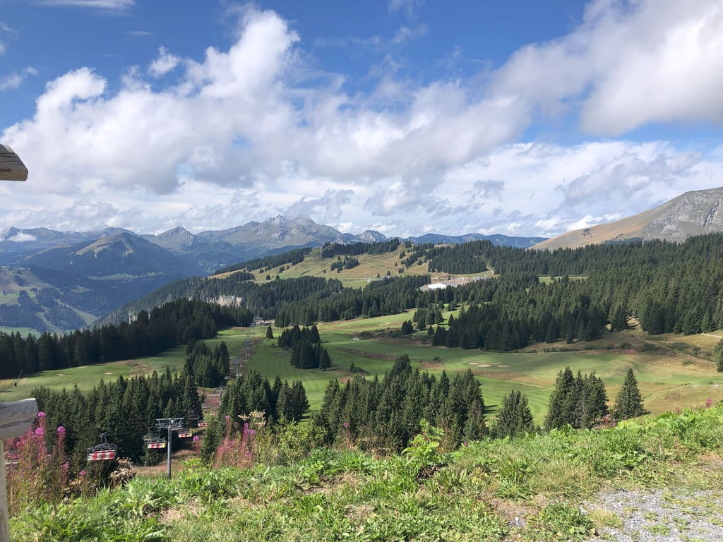
| Beautiful scenery |
| Hidden gem |
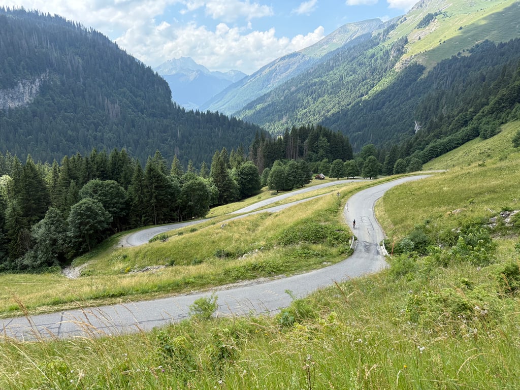
| 15 hairpin turns |
| #59 toughest climb of Haute Savoie |
| #25 most elevation gain of Haute Savoie |
| #27 longest climb of Haute Savoie |
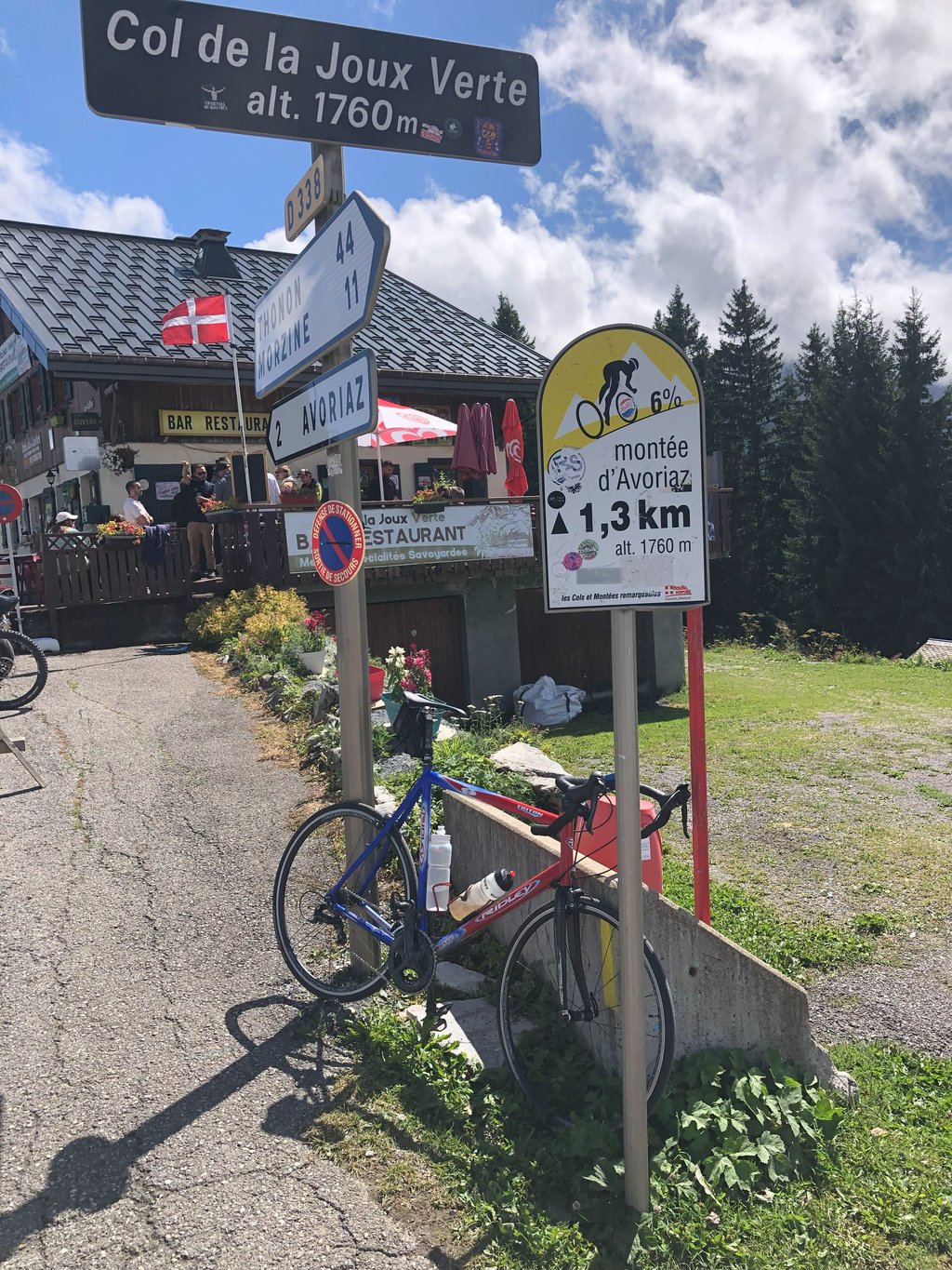
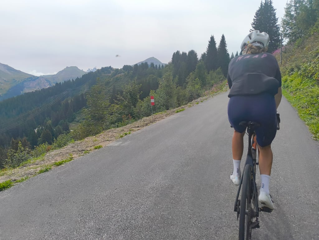
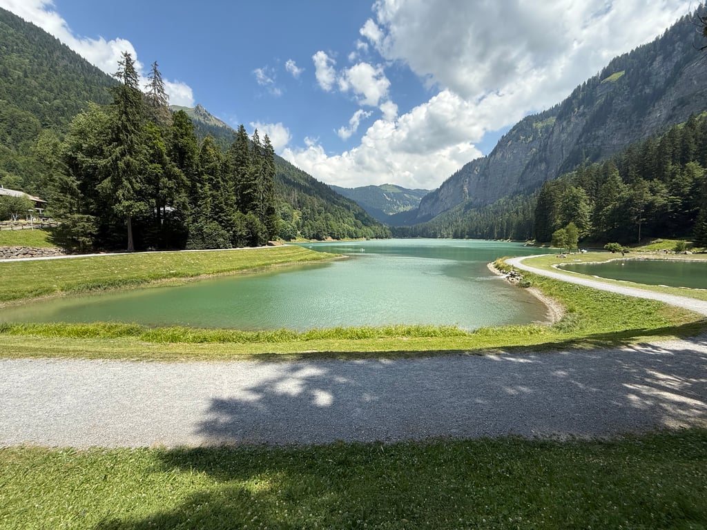
Col de la Joux Verte / Avoriaz from Montriond is a climb in the region Haute Savoie. It is 13.4 km long and bridges 824 m of vertical ascent with an average gradient of 6.1%, resulting in a difficulty score of 604. The top of the ascent is located at 1760 m above sea level. Climbfinder users shared 12 reviews of this climb and uploaded 36 photos.
Road names: Route du Lac & Route de la Joux Verte
5.0 by JeroenThis is an automatic translation, the original language is: Dutch.Beautiful climb with many faces. The first part up to the lake is a gift and not very difficult. After the (otherwise beautiful) lake comes a section with many hairpins. This part is well steep and continues steeply until the village of Les Lindarets. This village is home to a herd of goats that roam loose. Super fun! Further on in the village you'll find a water point. After the village, you cycle through a kind of half bowl of mountains. Really beautiful. I found the final part of the cl... read more
Welcome! Please activate your account if you would like to share something. Look for the verification email in your inbox.
If you want to upload your photos, you need to create an account. It only takes 1 minute and it's completely free.
Favourite climb in the Alps, and the fact it starts at my front door is a bonus! Easy wide road up to Lac Montriond, but after this it gets a bit tougher, from the turn off to Ardent car park there is a series of hairpins up to Les Linderets (the goat village) which is the hardest part of the climb but also the most picturesque. Once through the village the gradients ease off and the last 3 or 4 km through the woods to the junction with Route d'Avoriaz are at a pleasant and untroubling 6%, as long as you haven't gone too hard at the start. As another review has said, there is a nice alternative quieter climb up to the lake if you take the left at the montriond rond point.
Beautiful surroundings, lovely lake, with some fairly challenging sections here and there.
Mooie omgeving, lekker meer, regelmatig pittige stukjes.
After Lac de Montriond, the climb does get tough. You cycle at one point through a small tourist village where car traffic can't continue either, and goats on the road.
The climb ends on a big road, you can continue left for 1.5 km to a dull ski village Avoriaz. Nice view of the valley though (Morzine) Descent to Morzine is easy. Wide and good road surface.
Na het Lac de Montriond wordt de klim wel pittig. Je fiets op gegeven moment door een klein toeristisch dorpje waar het autoverkeer ook niet verder kan, en geiten op de weg.
De klim eindigt op een grote weg, je kunt links nog 1,5 km door naar een saai skidorp Avoriaz. Wel mooi uitzicht op het dal (Morzine) Afdaling naar Morzine gaat makkelijk. Breed en goed wegdek.
Perfect road condition apart from some of the edges. Views are incredible and keep coming
Lovely climb up past the Lake then the Cascade d’Ardent, steep past Alpine flowering meadows up to the village of Les Lindarets, (featuring free range goats) then through the Pine forest to Col de la Joux Verte.
a nice climb. nothing special until you’re past the lake and onto the hairpins: then the riding among the trees on a narrow path with excellent surface was fantastic. i didnt find the village with goats freely roaming around very attractive… the road continues after that between pine trees to the junction leading up to the ski resort Avoriaz. a wonderful descent.
Beautiful climb with many faces. The first part up to the lake is a gift and not very difficult. After the (otherwise beautiful) lake comes a section with many hairpins. This part is well steep and continues steeply until the village of Les Lindarets. This village is home to a herd of goats that roam loose. Super fun! Further on in the village you'll find a water point.
After the village, you cycle through a kind of half bowl of mountains. Really beautiful. I found the final part of the climb quite tough because the climb is quite long after all. If you want to get to Avoriaz at the end of the climb, another kilometre of climbing is added. This ski village was completely deserted at the end of September. For a bite to eat or a drink, you're better off in Morzine around this time of year.
Prachtige klim met vele gezichten. Het eerste stuk tot het meer krijg je cadeau en is niet zo moeilijk. Na het (overigens prachtige) meertje komt een stuk met veel haarspeldbochten. Dit deel is goed steil en loopt steil door tot het dorpje Les Lindarets. In dit dorpje woont een kudde geiten die los rondlopen. Superleuk! Verderop in het dorpje vind je een waterpunt.
Na het dorpje fiets je door een soort halve kom van bergen. Echt prachtig. De finale van de klim vond ik best pittig omdat de klim toch wel lang is. Wil je aan het einde van de klim naar Avoriaz, komt er nog een kilometer klimmen bij. Dit skidorpje was eind september volledig uitgestorven. Voor een hapje of een drankje kan je rond deze tijd van het jaar beter in Morzine zijn.
Great climb with beautiful landscapes, moreover we pass by the lake of Montriond, the waterfall of Ardent and the Lindarets, there is traffic but it's ok. If I had to give an advice it would be not to start too fast because there are 3 very difficult km which follow each other until Lindarets and the last two are not easy either but they are more accessible.
Super montée avec de magnifiques paysages, de plus on passe par le lac de Montriond, la cascade d’Ardent et les Lindarets, il y a de la circulation mais ça va. Si je devais donner un conseil ce serait de ne pas partir trop vite car il y a 3km très difficile qui s’enchaîne jusqu’à Lindarets et les deux derniers ne sont pas simples non plus mais ils sont plus abordables.
Breathtakingly beautiful climb! By far the best I have done! You start on a big road that is actually more of a runner than a climb. After the lake, the road narrows and becomes significantly steeper until you reach the ski area. Here, you pass beautiful hairpin bends that give you wonderful views of the valley at every turn. After the goat village and the ski area, the percentages decrease and you can enjoy a winding forest road. The last kilometre to Avoriaz is on a large and wide road. The view at the top is magnificent!
Adembenemend mooie klim! Veruit de mooiste die ik al gedaan heb! Je start op een grote weg die eigenlijk meer een loper dan een klim is. Na het meer versmalt de weg zich en wordt deze beduidend steiler tot aan het skigebied. Hier ga je langs mooie haarspeldbochten die je bij elke draai prachtige uitzichten over de vallei geven. Na het geitendorp en het skigebied worden de percentages terug wat minder groot en kan je genieten van een slingerende bosweg. De laatste kilometer naar Avoriaz is over een grote en brede weg. Het uitzicht op de top is prachtig!
Affordable ascent in a bucolic setting and magnificent landscapes. Nice series of switchbacks before the Lindarets. The last few km are easier. Not much traffic if you go early in the morning. You certainly have to watch out for goats in the village of Les Lindarets. I did not see them there because they were milking!
Montée abordable dans un cadre bucolique et des paysages magnifiques. Bel enchaînement de lacets avant les Lindarets. Les derniers km sont plus faciles. Pas beaucoup de circulation si on y va tôt le matin. Il faut certainement faire attention aux chèvres dans le village des Lindarets. Je ne les y ai pas vues car elles étaient à la traite!
The alternative for the climb to Avoriaz, which is regularly done during the Tour (last time in 2010). This climb is slightly more difficult and also more beautifully situated. It is a narrow road and you should certainly when descending for the sheep herds on the road, especially at les Lindaretes. Because of the many bends you always have new views on what you've done, but also on what is to come. Highly recommended!
Hét alternatief voor de klim naar Avoriaz, die met enige regelmaat tijdens de Tour gedaan wordt (laatste keer 2010). Deze beklimming is iets moeilijker en ook mooier gelegen. Het is wel een smalle weg en je moet zeker bij het dalen uitkijken voor de schaapskuddes op de weg, vooral bij les Lindaretes. Door de vele bochten heb je steeds nieuwe uitzichten op wat je gedaan hebt, maar ook op wat er komen gaat. Een aanrader!
| 7 km/h | 01:54:50 |
| 11 km/h | 01:13:05 |
| 15 km/h | 00:53:35 |
| 19 km/h | 00:42:18 |
This page is better in the app