View on map
© MapLibre | OpenStreetMap contributors
1%
2%
4%
6%
8%
10%
12%
15%
20%

Bëttelerbësch from Bettel

3.0
3 reviews | Elevation profile | 3 photos
Tips nearby
Bëttelerbësch from Bettel
transparant thumb
transparant thumb
transparant thumb
transparant thumb
transparant thumb
Your achievable time
Calculating based on your best performances...
Relaxed
Maximum
W/kg
W/kg
W/kg
Analyse your climbing performance
Detailed insight into your climbing performance & automatically check off climbs
Based on your best performances.
Your best attempt:
Number of attempts:
Elevation profile Bëttelerbësch from Bettel

Statistics

Difficulty points 104
Length 2.3 km
Average gradient 6.4%
Steepest 100 metres 11.5%
Total ascent 146 m
Feedback about this climb?
Show climbs nearby Export to GPS device

Bëttelerbësch from Bettel is a climb in the region Nordstad. It is 2.3 km long and bridges 146 m of vertical ascent with an average gradient of 6.4%, resulting in a difficulty score of 104. The top of the ascent is located at 357 m above sea level. Climbfinder users shared 3 reviews of this climb and uploaded 3 photos.

Road name: Kierfechtswee
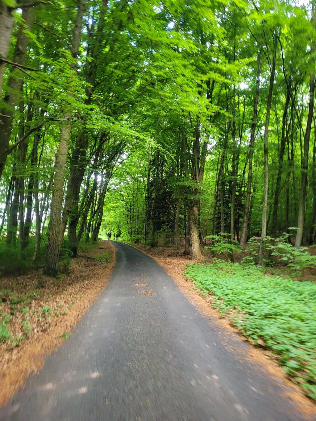
3.0 by Jarin
This is an automatic translation, the original language is: Dutch.
Nice long climb from Bettel that gets steeper for a while from the cemetery but then flattens out again. The climb continues gradually through the forest, but after exiting the forest the climb becomes uneven. The views are beautiful then, however.... read more

Photos (3)

Bëttelerbësch from Bettel
transparant thumb
transparant thumb
transparant thumb

Your uploads (max 4)

Welcome! Please activate your account if you would like to share something. Look for the verification email in your inbox.

If you want to upload your photos, you need to create an account. It only takes 1 minute and it's completely free.

  • Receive free climbfinder goodies for your reviews & photos.
  • Create a bucket list and check off conquered climbs.
  • Add missing climbs.
Continue with GoogleContinue with Google Continue with FacebookContinue with Facebook Continue with AppleContinue with Apple Sign up with email
By signing up you agree to our terms of service and confirm that you have read our privacy & content policy.

Reviews (3)

5.0
4.0
3.0
2.0
1.0
Jarin
1 y 3.0 via the Climbfinder app
This is an automatic translation, the original language is: Dutch. Show original

Nice long climb from Bettel that gets steeper for a while from the cemetery but then flattens out again. The climb continues gradually through the forest, but after exiting the forest the climb becomes uneven. The views are beautiful then, however.

Mooie lange klim vanuit Bettel die vanaf het kerkhof even steiler wordt maar daarna weeer wat afvlakt. De klim vervolgt geleidelijk door het bos, maar na het uitkomen van het bos wordt de klim onregelmatig. Het uitzicht is dan echter prachtig.

Bëttelerbësch from Bettel
Dashboard
J-M
1 y 3.0 via the Climbfinder app
This is an automatic translation, the original language is: Dutch. Show original

Road surface I think the first kilometres replaced is fine now

Wegdek is denk ik de eerste kilometers vervangen is nú prima

Dashboard
Panyagua
2 y 3.0
This is an automatic translation, the original language is: Dutch. Show original

Nice warm-up for other (steeper) climbs in the area. The first part you ride in the lee of the trees. The road surface is pretty lousy here and there and it is also quite dark, so it is not recommended to descend hard here. Once at the top, you come to a beautiful plateau with picturesque views.

Mooie opwarmer voor andere (steilere) beklimmingen in de omgeving. Het eerste gedeelte rijd je in de luwte van de bomen. Het wegdek is er hier en daar vrij beroerd aan toe en ook is het behoorlijk donker, waardoor het af te raden is om hier hard te dalen. Eenmaal boven kom je op een mooi plateau met schilderachtige uitzichten.

Dashboard

Climbing times

7 km/h 00:19:33
11 km/h 00:12:26
15 km/h 00:09:07
19 km/h 00:07:12

Road surface condition

0% 0% 100%
Based on 1 vote
Share your knowledge. What was the road condition during your ascent?

Traffic

0% 0% 0%
Based on 0 votes
Your experience counts. How much traffic did you encounter during the climb?

Frequently Asked Questions

Bëttelerbësch can be cycled from 5 sides. Mur de Vianden is the most popular side, but the summit can also be reached via Bëttelerbësch from Bettel, Fuerner Knupp from Vianden, Fuerner Knupp from Seltz & Fuerner Knupp from Bettel.

You don't need special gearing for Bëttelerbësch from Bettel. The slope isn't long or steep enough to require much shifting down. You can conquer this climb on power alone. However, a compact gearing system with a smallest front chainring of 34 and largest rear sprocket of 28 or 30 is always nice if you enjoy cycling uphill. This helps maintain a smooth cadence.

Bëttelerbësch from Bettel is a 4th-category climb. A sprint to the top is usually not an option, and untrained riders will definitely feel it in their legs. For trained cyclists, it is a great training climb.

Bëttelerbësch from Bettel is 2.3 km long.

The average gradient of Bëttelerbësch from Bettel is 6.4%.

Bëttelerbësch from Bettel has a steepest segment with an average gradient of 11.5%.

The summit of Bëttelerbësch from Bettel is at 357 m.

At a slow pace of 7 km/h, it takes about 00:19:33 to climb Bëttelerbësch from Bettel. At 11 km/h the time is 00:12:26, and at 15 km/h 00:09:07. For the fastest cyclists, 00:07:12 is an achievable time.

Bëttelerbësch from Bettel is located in the region Nordstad in Luxembourg.

This page is better in the app

Climbfinder app
Climbfinder
(Free)
Open